Hyperspectral Remote Sensing
Table of Contents
- What is Hyperspectral Remote Sensing?
- The Hyperspectral Data Cube
- How Hyperspectral Sensors Work
- The Electromagnetic Spectrum and Spectral Signatures
- Data Acquisition Techniques
- Processing and Analyzing Hyperspectral Data
- Atmospheric and Radiometric Correction
- Dimensionality Reduction
- Spectral Unmixing and Endmember Extraction
- Major Applications of Hyperspectral Remote Sensing
- 1. Agriculture and Precision Farming
- 2. Geology, Mining, and Mineral Exploration
- 3. Environmental Monitoring and Water Quality
- 4. Forestry, Ecology, and Vegetation Analysis
- 5. Defense, Security, and Target Detection
- Advancements in Hyperspectral Platforms
- Satellites and Spaceborne Sensors
- Unmanned Aerial Vehicles (UAVs) and Drones
- Airborne and Ground-Based Systems
- Challenges and Limitations
- 1. Massive Data Volume and Storage
- 2. Processing Complexity and Expert Knowledge
- 3. Atmospheric Interference and Calibration
- 4. Cost and Accessibility
- Future Trends in Hyperspectral Technology
- Integration of Artificial Intelligence and Machine Learning
- Miniaturization and Nanosatellite Constellations
- Sensor Fusion: Combining Hyperspectral with LiDAR and SAR
- Conclusion
- Frequently Asked Questions
rsandgis.me
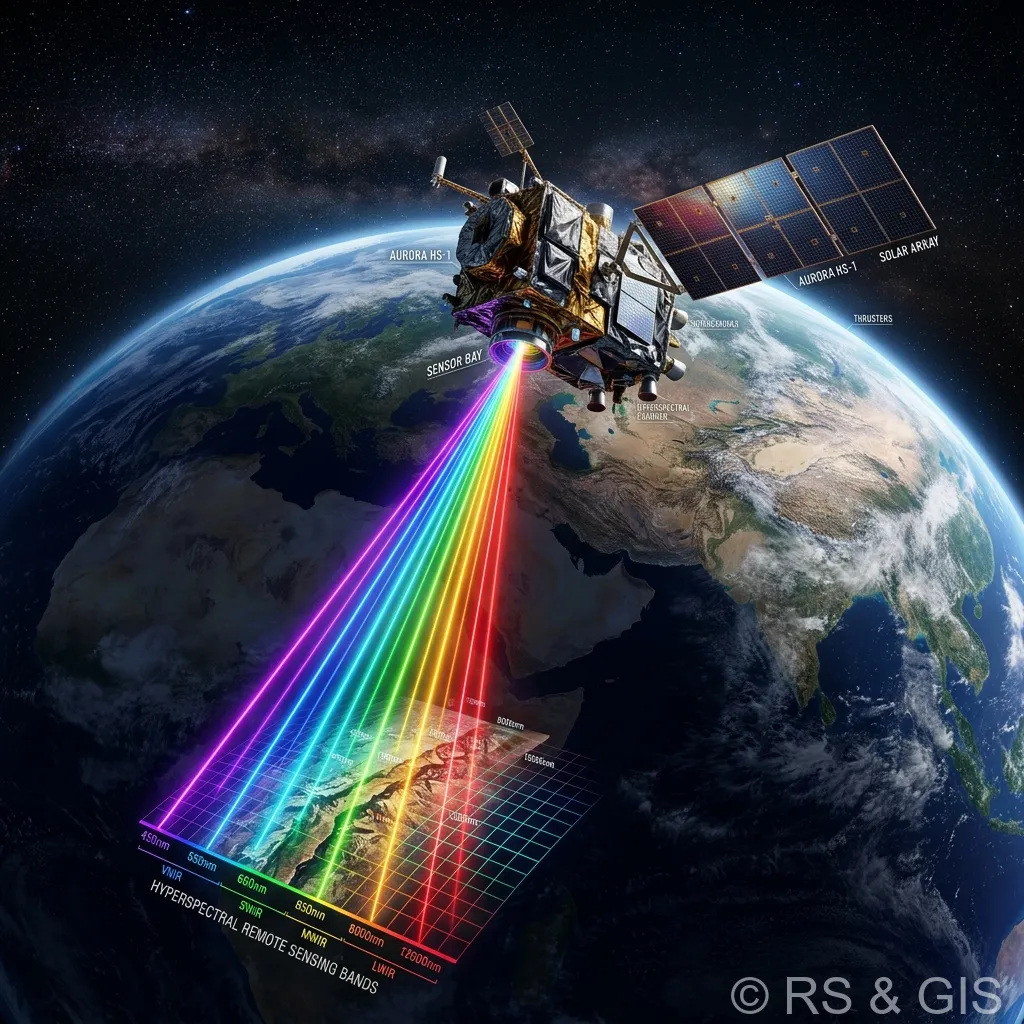
In the rapidly evolving field of Earth observation and spatial analytics, few technologies have revolutionized our understanding of the physical world as profoundly as hyperspectral remote sensing. Also known as imaging spectroscopy, this advanced technology goes beyond the limitations of human vision and traditional optical cameras. By capturing and analyzing data across hundreds of narrow, contiguous spectral bands, hyperspectral imaging enables scientists, engineers, and researchers to identify materials and extract critical insights that are otherwise invisible to the naked eye.
This deeply guide explores the mechanics, applications, processing techniques, and future potential of hyperspectral remote sensing. Whether you are an environmental scientist, an agriculture specialist, a geologist, or a technology enthusiast, understanding the nuances of this technology is key to unlocking its full potential in solving complex global challenges.
What is Hyperspectral Remote Sensing?
Fundamentally, hyperspectral remote sensing involves the acquisition of electromagnetic information across a vast array of spectral bands. Every material on Earth, whether it is a specific mineral, a type of vegetation, a water body, or a man-made structure, interacts with light uniquely. These interactions involve reflection, absorption, and emission of electromagnetic energy.
Traditional RGB cameras capture light in three broad bands (Red, Green, and Blue). Multispectral sensors, such as those found on Landsat or Sentinel-2 satellites, capture data in 4 to 15 broader bands. In contrast, hyperspectral sensors measure energy in hundreds of narrow bands, typically between 1 and 10 nanometers wide. This continuous spectrum spans the visible, near-infrared (VNIR), and shortwave infrared (SWIR) regions, creating a highly detailed "spectral signature" or "fingerprint" for every pixel in an image.
The Hyperspectral Data Cube
One of the foundational concepts of hyperspectral remote sensing is the spectral data cube. Because a sensor captures spatial information (X and Y dimensions) simultaneously with continuous spectral information (the Z dimension, or wavelength), the resulting data structure is a three-dimensional cube. By extracting a single pixel from this cube, an analyst can plot a continuous spectral reflectance curve. This curve is what allows for the precise identification of materials based on their chemical and physical properties.
For instance, while a multispectral image might show a forest as generally "green," a hyperspectral data cube can differentiate between various tree species, detect early stages of disease, and even measure the water and chlorophyll content within the leaves.
How Hyperspectral Sensors Work
To understand the power of hyperspectral imaging, it is essential to explore the physical and technical mechanisms that drive the technology.
The Electromagnetic Spectrum and Spectral Signatures
The electromagnetic spectrum encompasses all types of electromagnetic radiation, ranging from short-wavelength gamma rays to long-wavelength radio waves. Hyperspectral remote sensing typically operates in the optical range (400 to 2500 nanometers). When sunlight hits the Earth's surface, chemical bonds within materials absorb certain wavelengths and reflect others. The specific pattern of reflectance across the spectrum constitutes a material's unique spectral signature.
Data Acquisition Techniques
Hyperspectral sensors utilize different scanning methodologies to build the data cube. The three most common architectures are:
- Pushbroom (Line Scanning): The sensor captures a single spatial line of pixels across all spectral bands simultaneously. As the platform (e.g., satellite or drone) moves forward, successive lines are captured to build the 3D cube. This is the most common method for airborne and spaceborne platforms.
- Whiskbroom (Point Scanning): A system of rotating mirrors directs light from a single point on the ground into the spectrometer. The mirror sweeps back and forth across the track to create a line, and the forward motion of the platform builds the image.
- Snapshot (Staring Arrays): This newer technology captures the entire 3D data cube (both spatial and spectral dimensions) in a single integration time, much like a standard digital camera. While currently limited in spatial resolution compared to pushbroom sensors, snapshot imagers are highly valuable for dynamic, high-speed environments.
Processing and Analyzing Hyperspectral Data
The unparalleled detail provided by hyperspectral remote sensing comes at a cost: massive data volume and high computational complexity. Processing these rich datasets requires specialized algorithms and significant computational power.
Atmospheric and Radiometric Correction
Before hyperspectral data can be analyzed, it must undergo rigorous pre-processing. As light travels from the sun to the Earth and back to the sensor, it interacts with atmospheric gases (like water vapor and carbon dioxide) and aerosols. These interactions scatter and absorb light, altering the recorded signal. Atmospheric correction algorithms convert sensor radiance into true surface reflectance, ensuring that the spectral signatures match laboratory standards.
Dimensionality Reduction
A hyperspectral image can contain hundreds of bands, many of which are highly correlated and contain redundant information. To improve processing efficiency and reduce noise, analysts use dimensionality reduction techniques. The most common methods include Principal Component Analysis (PCA) and the Minimum Noise Fraction (MNF) transform. These techniques compress the useful variance of the dataset into a smaller number of bands, isolating noise and making the data more manageable.
Spectral Unmixing and Endmember Extraction
In reality, a single pixel (e.g., 30x30 meters on a satellite image) rarely contains just one material. It is usually a mixture of soil, vegetation, water, and shadow. Spectral unmixing is the mathematical process of decomposing a mixed pixel into its pure component spectra, known as endmembers, and determining the proportional abundance of each. Algorithms such as the Pixel Purity Index (PPI) and N-FINDR are heavily utilized in this phase.
Major Applications of Hyperspectral Remote Sensing
The ability to identify materials based on their chemical composition has opened the door to countless applications across various industries.
1. Agriculture and Precision Farming
In precision agriculture, hyperspectral imaging is a major advancement. By analyzing the subtle variations in plant reflectance, farmers and agronomists can:
- Detect Plant Stress and Disease: Hyperspectral sensors can identify changes in chlorophyll and water content before symptoms are visible to the human eye, allowing for early intervention.
- Optimize Fertilizer and Water Usage: By mapping nutrient deficiencies (such as nitrogen or phosphorus) at a granular level, farmers can apply fertilizers only where needed, reducing costs and environmental runoff.
- Classify Crop Species and Weeds: Precise spectral signatures enable the differentiation of specific crop varieties and the identification of invasive weed species for targeted herbicide application.
2. Geology, Mining, and Mineral Exploration
Geologists have long relied on hyperspectral remote sensing for mapping the Earth's surface. Minerals have distinct absorption features in the SWIR (Shortwave Infrared) region due to molecular vibrations of hydroxyl, carbonate, and sulfate groups.
- Mineral Mapping: Companies use airborne and spaceborne hyperspectral data to map alteration zones and pinpoint deposits of gold, copper, and rare earth elements without setting foot on the ground.
- Mine Tailings Monitoring: Hyperspectral data helps monitor the environmental impact of mining operations, such as identifying acid mine drainage and tracking heavy metal contamination in surrounding soils.
3. Environmental Monitoring and Water Quality
Protecting ecosystems requires vast amounts of accurate spatial data. Hyperspectral remote sensing excels in characterizing both terrestrial and aquatic environments.
- Water Quality Assessment: Sensors can measure the concentration of chlorophyll-a, suspended sediments, and colored dissolved organic matter (CDOM) in lakes, rivers, and coastal waters. This is critical for detecting harmful algal blooms and monitoring pollution.
- Oil Spill Detection: Hyperspectral imagery can accurately distinguish between water and oil, estimate the thickness of an oil slick, and guide cleanup operations.
- Soil Mapping: The technology is used to map soil properties, including organic carbon content, moisture levels, and salinity, contributing to better land management practices.
4. Forestry, Ecology, and Vegetation Analysis
Forest management relies on accurate inventories and health assessments. Hyperspectral remote sensing provides the tools to:
- Map Biodiversity: High-resolution spectral data allows for the mapping of individual tree species across vast forested areas, aiding in biodiversity conservation efforts.
- Assess Biomass and Carbon Sequestration: By combining spectral data with LiDAR (Light Detection and Ranging), researchers can accurately estimate above-ground biomass and track the carbon storage potential of forests.
- Wildfire Management: Hyperspectral data can map dry vegetation and fuel loads, helping to predict wildfire risks and manage post-fire ecosystem recovery.
5. Defense, Security, and Target Detection
In military and security contexts, the ability to uncover hidden information is paramount. Hyperspectral sensors can defeat artificial camouflage by distinguishing between the spectral signature of a real tree and a green-painted tarp. It is also used for detecting disturbed earth (indicating buried explosives), monitoring borders, and conducting broad-area search and rescue operations.
Advancements in Hyperspectral Platforms
Historically, hyperspectral remote sensing was limited to expensive, bulky airborne systems and laboratory environments. Today, technological advancements have democratized access to this data across multiple platforms.
Satellites and Spaceborne Sensors
Early spaceborne hyperspectral missions, such as NASA's Hyperion on the EO-1 satellite, proved the viability of orbital imaging spectroscopy. Today, a new generation of satellites is providing unparalleled global coverage. Missions like the Italian PRISMA, the German EnMAP, and the upcoming NASA SBG (Surface Biology and Geology) mission are delivering high-quality, open-access hyperspectral data to the global scientific community. Also, commercial space companies are deploying constellations of microsatellites equipped with hyperspectral payloads, ensuring high-revisit rates for dynamic monitoring.
Unmanned Aerial Vehicles (UAVs) and Drones
The miniaturization of optical components has led to the development of lightweight hyperspectral cameras suitable for UAVs. Drones offer an ultra-high spatial resolution (often at the centimeter level) and the flexibility to fly under cloud cover. This platform is highly favored in precision agriculture, local environmental monitoring, and infrastructure inspection, providing a cost-effective alternative to manned aircraft surveys.
Airborne and Ground-Based Systems
Manned aircraft remain the gold standard for regional-scale mapping, offering an optimal balance between spatial coverage and resolution. Ground-based and laboratory hyperspectral systems are also widely used for core logging in mining, quality control in food processing, and creating the reference spectral libraries necessary for interpreting airborne and satellite data.
Challenges and Limitations
Despite its incredible capabilities, hyperspectral remote sensing is not without its hurdles. Understanding these challenges is crucial for successful implementation.
1. Massive Data Volume and Storage
A single hyperspectral image can easily exceed several gigabytes in size. Storing, transmitting, and processing hundreds of contiguous bands requires robust IT infrastructure, significant bandwidth, and advanced data management protocols.
2. Processing Complexity and Expert Knowledge
Unlike standard aerial photography, interpreting hyperspectral data requires specialized software (such as ENVI or ERDAS IMAGINE) and a deep understanding of physics, optics, and mathematics. The scarcity of trained remote sensing analysts and spectroscopy experts remains a bottleneck for widespread industry adoption.
3. Atmospheric Interference and Calibration
Because hyperspectral sensors measure precise physical properties, they are highly sensitive to atmospheric conditions. Clouds, shadows, and atmospheric scattering can severely distort the data. Accurate atmospheric correction requires detailed meteorological data and complex algorithms, which can introduce uncertainties if not performed correctly.
4. Cost and Accessibility
While the cost of hardware is decreasing, professional-grade hyperspectral cameras and the associated calibration equipment remain expensive. For many small-to-medium enterprises, the barrier to entry is high, although the rise of Data-as-a-Service (DaaS) models from commercial satellite providers is beginning to alleviate this issue.
Future Trends in Hyperspectral Technology
As we look to the future, several key trends are poised to accelerate the adoption and impact of hyperspectral remote sensing.
Integration of Artificial Intelligence and Machine Learning
The sheer volume and complexity of hyperspectral data make it a perfect candidate for AI and Machine Learning (ML). Deep learning models, specifically Convolutional Neural Networks (CNNs), are increasingly being used to automate classification, object detection, and spectral unmixing. AI can uncover subtle, non-linear relationships within the spectral data cube, drastically reducing processing time and enabling real-time analysis on edge devices (such as drones or satellites).
Miniaturization and Nanosatellite Constellations
Advancements in micro-optics and sensor design are continuously reducing the size, weight, and power (SWaP) requirements of hyperspectral instruments. This miniaturization is fueling the rise of nanosatellite constellations, which will provide daily, or even hourly, global hyperspectral coverage. This temporal frequency will revolutionize monitoring capabilities for agriculture, disaster response, and climate change tracking.
Sensor Fusion: Combining Hyperspectral with LiDAR and SAR
No single sensor can capture everything. The future of remote sensing lies in sensor fusion, combining the rich chemical and material data of hyperspectral imaging with the structural and topographical data of LiDAR, and the all-weather, day-and-night capabilities of Synthetic Aperture Radar (SAR). Fusing these datasets yields highly accurate, multidimensional models of the Earth's surface, essential for complex urban planning, forestry management, and geological exploration.
Conclusion
Hyperspectral remote sensing is a transformative technology that has fundamentally changed our ability to observe, measure, and understand the physical world. By capturing the continuous spectrum of light, it reveals the hidden chemical and physical properties of the environment, offering unparalleled analytical depth.
From maximizing crop yields and exploring for critical minerals to monitoring the health of our oceans and forests, the applications are as vast as the electromagnetic spectrum itself. While challenges regarding data volume, processing complexity, and cost remain, the rapid integration of artificial intelligence, the deployment of spaceborne constellations, and the miniaturization of drone-based sensors are rapidly overcoming these barriers.
As we face urgent global challenges such as climate change, food security, and resource scarcity, the insights provided by hyperspectral remote sensing will be indispensable. Embracing this technology is not just an investment in advanced optics; it is an investment in a more sustainable, data-driven future for our planet.
Frequently Asked Questions
What is the difference between multispectral and hyperspectral remote sensing?
Multispectral sensors (like Landsat) collect data in a few broad, separated spectral bands (e.g., 4 to 10). Hyperspectral sensors collect data in hundreds of narrow, contiguous spectral bands, creating a continuous spectrum that allows for the identification of specific materials and chemical compositions.
What is a spectral signature?
A spectral signature is the unique pattern of reflectance and absorption of electromagnetic radiation by a specific material across different wavelengths. Hyperspectral imaging uses these signatures to definitively distinguish between similar-looking materials, such as different species of trees or types of minerals.
What are the main applications of hyperspectral imaging?
Hyperspectral data is heavily used in mineral exploration to identify specific ore deposits, in precision agriculture to detect crop stress and nutrient deficiencies before they are visible to the naked eye, and in environmental monitoring to track water quality and chemical spills.
