Mapping Coral Reef Bleaching Using Satellite Imagery
Table of Contents
- The Ecological Significance and Threat of Coral Bleaching
- Introduction to Remote Sensing in Dynamic Marine Environments
- Multi-Spectral Satellite Imagery for Coastal Applications
- The Critical Role of Different Spectral Bands in Marine Analysis
- Core Methodologies for Image Processing, Correction, and Analysis
- Radiometric Calibration and Atmospheric Correction
- Specular Sunglint Removal Techniques
- Advanced Water Column Correction Algorithms
- Advanced Classification Algorithms and Machine Learning
- Unsupervised Classification Methods
- Supervised Classification Methodologies
- Object-Based Image Analysis (OBIA)
- Satellite Systems Used for Monitoring Coral Reefs
- The Historic Landsat Program
- The ESA Sentinel-2 Constellation
- High-Resolution Commercial Satellite Platforms
- Ongoing Challenges and Inherent Limitations in the Field
- The Persistent Problem of Depth and Coastal Turbidity
- Spectral Confusion and Biological Mimicry
- Unpredictable Atmospheric and Environmental Constraints
- Integrating Satellite Data with Ground-Truthing and UAV Drones
- The Future Horizon: AI and Global Monitoring Initiatives
- Conclusion
- Frequently Asked Questions
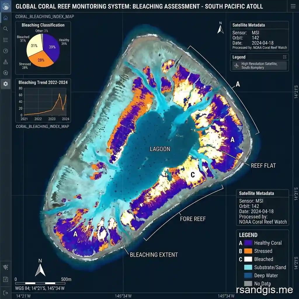
rsandgis.me
Coral reefs are among the most vibrant, structurally complex, and biologically diverse ecosystems on the planet, often accurately described as the rainforests of the sea. These extraordinary marine habitats are home to thousands of species, creating a delicate balance of life beneath the ocean's surface. But anthropogenically driven climate change and the resulting unparalleled rise in global ocean temperatures have severely threatened their long-term survival, leading to widespread, catastrophic degradation. Among the many modern scientific conservation strategies and environmental monitoring paradigms, mapping coral reef bleaching using satellite imagery stands out as an absolutely indispensable approach. By intelligently leveraging multi-spectral remote sensing technologies, marine scientists, spatial analysts, and conservationists can effectively monitor vast tracts of remote ocean that would otherwise be completely impossible and cost-prohibitive to survey manually. This comprehensive article delves deeply into the intricate techniques, specialized methodologies, and cutting-edge technologies that make mapping coral reef bleaching using satellite imagery a vital, world-saving tool for preserving global marine biodiversity.
The Ecological Significance and Threat of Coral Bleaching
Coral reefs cover less than one percent of the Earth's total ocean floor, yet they remarkably support approximately twenty-five percent of all known marine life. They provide critical habitats, breeding grounds, and nurseries for thousands of species of fish, invertebrates, and marine mammals. Beyond their biological importance, coral reefs protect vulnerable coastlines from the devastating impacts of coastal erosion, storm surges, and hurricanes by acting as natural breakwaters. Also, they support the economic livelihoods of hundreds of millions of people globally through eco-tourism, commercial fisheries, and the potential for novel biochemical discoveries. The biological foundation of these incredibly rich ecosystems is the obligate symbiotic relationship between the coral animal (the polyp) and microscopic, photosynthetic dinoflagellates commonly called zooxanthellae, which live harmoniously within the coral's internal tissues. The symbiotic algae provide the host corals with up to ninety percent of their required nutritional energy through the process of photosynthesis, while also giving the reefs their iconic, vibrant, and diverse colors.
When these delicate corals are subjected to intense environmental stress, most notably prolonged periods of elevated sea surface temperatures anomalies, often exacerbated by El Niño events, the fragile symbiotic relationship breaks down. In response to the thermal stress, the coral polyps expel their life-giving symbiotic algae. This rapid expulsion leaves the corals' underlying white calcium carbonate skeletons entirely visible through their transparent tissues, resulting in a stark, ghostly appearance. This widespread phenomenon is scientifically known as coral bleaching. While bleached corals are not immediately dead, they are severely compromised, highly vulnerable to starvation, and highly susceptible to various marine diseases. If the stressful environmental conditions persist for an extended period, mass mortality of the coral colonies can quickly occur. Over the past few decades, mass bleaching events have rapidly increased in both frequency and severity, devastating large, interconnected portions of the Great Barrier Reef in Australia, the Mesoamerican Barrier Reef System, and other significant reef systems across the globe. Timely detection, continuous monitoring, and rapid response are absolutely crucial for implementing adaptive management strategies, which is exactly why orbital remote sensing has become a foundational cornerstone of modern marine conservation efforts.
Introduction to Remote Sensing in Dynamic Marine Environments
In the broadest sense, remote sensing involves acquiring detailed information about a physical object, area, or environmental phenomenon without making any direct physical contact with it. In the context of marine environments and oceanography, satellite imagery provides a macro-level, orbital perspective that is absolutely essential for studying large-scale ecological changes across massive geographic expanses. The core advantage of satellite remote sensing lies inherently in its unparalleled ability to offer repeated, objective, standardized, and synoptic observations of the Earth's surface over long periods. This temporal consistency allows researchers to establish historical baselines and accurately track gradual or sudden environmental deviations.
But observing submerged biological habitats presents highly unique optical and physical challenges when directly compared to traditional terrestrial remote sensing of forests or agriculture. The oceanic water column dynamically scatters and absorbs incoming solar radiation (light), significantly altering and attenuating the spectral signature of the underlying benthic (bottom-dwelling) communities before that light can bounce back to the satellite sensor in space. To accurately and reliably assess the true health of shallow coral reefs, remote sensing scientists must carefully employ highly sophisticated mathematical algorithms. These algorithms are required to explicitly correct for atmospheric interference (such as aerosols and water vapor), sunglint reflecting off the turbulent water surface, and the severe attenuating effects of the water column itself. Recent technological advancements in multi-spectral and hyper-spectral orbital sensors have dramatically improved both the spatial resolution (pixel size) and spectral resolution (number of color bands) available to researchers. This technological leap allows for much more detailed, nuanced, and accurate mapping of complex benthic habitats than was previously thought possible.
Multi-Spectral Satellite Imagery for Coastal Applications
Multi-spectral satellite imagery involves capturing digital image data at specific, predefined frequencies (or bands) across the electromagnetic spectrum. The incoming wavelengths of light are carefully separated by optical filters into different, distinct bands, typically including visible light (such as red, green, and blue) and various ranges of near-infrared and shortwave-infrared. Different physical materials, whether they are concrete, dense forest, or submerged coral, reflect and absorb light in highly characteristic, measurable ways, known as their unique spectral signatures. By meticulously analyzing these specific signatures, scientists can confidently distinguish between various types of land cover and complex marine environments. This analytical process is particularly vital when examining highly dynamic marine habitats where subtle shifts in light reflection dictate the crucial difference between a thriving, healthy ecosystem and a dying, bleached one.
The Critical Role of Different Spectral Bands in Marine Analysis
In the specific context of shallow-water benthic mapping, the visible bands of the electromagnetic spectrum (blue, green, and red) are by far the most critical because they actually possess the physical ability to penetrate the water column. Understanding exactly how these specific bands interact with the ocean water and its underlying substrate is the absolute key to mapping coral reef bleaching using satellite imagery effectively and accurately.
- Coastal Blue Band (400-450 nm): This exceptionally short-wavelength band offers the absolute greatest water penetration capability of any optical band, making it essential for mapping deeper reef structures and capturing accurate bathymetric (depth) data. It is very frequently employed in complex algorithms to explicitly correct for deep-water scattering and to derive highly accurate digital depth models of the seafloor.
- Blue Band (450-510 nm): The standard blue band penetrates clear, oligotrophic water highly effectively and is extremely useful for distinguishing between different broad types of submerged vegetation and various coral morphologies. Due to its impressive penetration depth, it remains one of the absolute foundational bands for assessing overall reef geography and spatial extent.
- Green Band (510-580 nm): Green light is heavily reflected by chlorophyll-containing organisms, specifically including the vital zooxanthellae living in healthy corals, as well as various forms of marine macroalgae. It is highly useful for directly assessing the biological health and spatial density of benthic vegetation, making it an excellent, reliable proxy for detecting the presence of active, photosynthetic symbionts within living coral tissues.
- Red Band (600-690 nm): Red light is very quickly and heavily absorbed by the water column, strictly limiting its practical use to very shallow coastal areas (typically less than two or three meters deep). But despite this limitation, it is highly sensitive to the presence of chlorophyll and can help researchers definitively differentiate between exposed, shallow corals and dense algal mats in near-shore intertidal reef zones.
- Near-Infrared (NIR) Band (700-1000 nm): NIR light is almost entirely and immediately absorbed by liquid water, meaning it reflects almost absolutely nothing over deep, open water. This stark contrast makes the NIR band absolutely ideal for precisely delineating coastlines, quickly identifying emergent reef crests that break the surface, and effectively correcting for specular sunglint bouncing off the water surface.
Core Methodologies for Image Processing, Correction, and Analysis
Mapping coral reef bleaching is a highly complex, multi-step process that goes far beyond simply looking at a pretty satellite photograph on a computer screen. The raw, uncalibrated data captured by satellites traveling at thousands of miles per hour must undergo rigorous, mathematically intense pre-processing and specialized corrections before the underlying biological information can be accurately extracted. Only through careful, step-by-step, scientifically validated methodologies can spatial analysts derive the robust analytics needed to classify reef health metrics with absolute confidence.
Radiometric Calibration and Atmospheric Correction
The very first, foundational step in any serious remote sensing workflow is radiometric correction, which mathematically converts the raw, arbitrary digital numbers captured by the satellite sensor into standardized, physical units of radiance. Following this critical calibration, atmospheric correction is meticulously applied to remove the confounding scattering and absorption effects of various gases, aerosols, and water vapor present in the Earth's atmosphere. Since the actual light signal reaching the satellite sensor from the ocean bottom is often less than 10% of the total signal recorded (with the rest being atmospheric noise), highly accurate atmospheric correction is absolutely critical for success. Even small, seemingly insignificant errors in atmospheric correction can completely obscure the subtle spectral differences between a healthy coral and a bleached coral, leading directly to false positives, false negatives, or entirely missed bleaching events.
Specular Sunglint Removal Techniques
Sunglint occurs naturally when incoming sunlight reflects specularly off the undulating surface of the ocean water, creating a blinding, localized glare that completely prevents the optical sensor from seeing the ocean floor below. Because ocean water surfaces are rarely perfectly calm and flat, sunglint can severely affect and corrupt large portions of an acquired image. To combat this, scientists intelligently use the Near-Infrared (NIR) band, which is heavily absorbed by water, to mathematically estimate and subsequently subtract the glint from the visible bands. If a specific pixel over open water shows significant reflectance in the NIR band, it is safely assumed to be entirely glint, and a proportional, calculated amount of reflectance is systematically subtracted from the visible bands to reveal the submerged benthic features beneath the glare.
Advanced Water Column Correction Algorithms
By far, the most notoriously challenging aspect of marine optical remote sensing is dealing with the physics of the water column itself. Water physically absorbs and scatters light at different rates depending on the wavelength, meaning that a patch of coral reef at a depth of 10 meters will appear spectrally very different from the exact same patch of reef at a depth of only 2 meters. Water column correction algorithms boldly attempt to mathematically strip away the optical effects of the water entirely to reveal the true, unattenuated bottom reflectance of the seafloor.
A historically commonly used method is the Depth-Invariant Index (DII) originally developed by Lyzenga in the late 1970s and early 1980s. This empirical approach cleverly uses the known relationship between the rapid attenuation of light in different spectral bands to mathematically create an index that is completely independent of the water depth. But more modern, computationally intensive physics-based approaches use complex radiative transfer models to explicitly simulate the physical behavior of light as it travels down through the atmosphere, into the water column, reflects off the bottom, and travels back up to the sensor. This advanced simulation allows for the simultaneous, highly accurate estimation of bathymetry, water quality parameters, and true bottom reflectance. Implementing these robust models ensures high precision and accuracy when executing the methodology of mapping coral reef bleaching using satellite imagery over highly variable, complex underwater topography.
Advanced Classification Algorithms and Machine Learning
Once the multi-spectral imagery has been meticulously corrected for atmospheric noise, surface glint, and water column attenuation, the critical next step is to accurately classify the individual pixels into different, ecologically meaningful benthic categories. These categories typically include healthy coral, bleached coral, various types of macroalgae, bare sand, or coral rubble. Modern computational advances and the rise of artificial intelligence have completely ushered in a golden era of algorithmic sophistication, enabling researchers to process significantly larger datasets faster and far more accurately than ever before in human history.
Unsupervised Classification Methods
In unsupervised classification, autonomous computer algorithms group pixels with mathematically similar spectral characteristics into distinct clusters without any prior human knowledge or input regarding what those clusters might represent in reality. This specific method is exceptionally fast and requires very minimal human intervention, making it highly useful for initial, broad exploratory analysis across vast, completely unsurveyed reef complexes in remote areas of the world. But the resulting mathematical clusters must still be carefully, manually identified and properly labeled by an experienced marine ecologist, which can be exceedingly difficult without robust, concurrent field data or deep localized ecological knowledge of the specific reef system being studied.
Supervised Classification Methodologies
Conversely, supervised classification heavily relies on explicit training data provided by the user. Scientists carefully select representative sample areas (known as Regions of Interest, or ROIs) for each specific benthic category based on extensive in-water field surveys, drone data, or very high-resolution commercial imagery. The classification algorithm then deeply analyzes the spectral signatures of these specific training pixels and uses advanced statistical methods to accurately classify the rest of the unknown image. Common, highly effective supervised algorithms include Maximum Likelihood, Support Vector Machines (SVM), and Random Forests. Random Forests, a popular ensemble learning method that operates by constructing a massive multitude of individual decision trees and outputting the consensus, has proven particularly effective and reliable in benthic habitat mapping. This is primarily due to its inherent robustness against data noise, outliers, and statistical overfitting in highly complex, heterogeneous underwater environments.
Object-Based Image Analysis (OBIA)
Traditional classification methods typically operate on a strict pixel-by-pixel basis, which can unfortunately result in a noisy, visually confusing salt-and-pepper effect, especially when utilizing ultra-high-resolution imagery where individual pixels might only represent a portion of a coral head. Object-Based Image Analysis (OBIA) directly addresses this issue by first intelligently segmenting the image into homogeneous, contiguous objects (groups of similar pixels) based heavily on combined spectral, spatial, and textural characteristics. The actual classification is then performed on these larger objects rather than on individual, isolated pixels. OBIA is highly advantageous and increasingly popular because it fundamentally allows scientists to incorporate crucial contextual information, such as the geometric shape of the reef structure, its texture, and its spatial relationship to surrounding deep water or sandy areas. This multi-layered, holistic context significantly improves overall classification accuracy and drastically minimizes false categorizations.
Satellite Systems Used for Monitoring Coral Reefs
The specific choice of satellite sensor plays a completely fundamental, make-or-break role in the overall success of any coral reef mapping project. Different satellite platforms inherently offer wildly varying trade-offs between spatial resolution (the physical size of the pixels on the ground), spectral resolution (the number and specific width of the optical color bands), and temporal resolution (exactly how often the satellite revisits and images a specific location on Earth). Deeply understanding the specific physical capabilities and limitations of each satellite constellation is absolutely essential to effectively and properly deploy the practice of mapping coral reef bleaching using satellite imagery on a global scale.
The Historic Landsat Program
The joint NASA and USGS Landsat program has famously provided continuous, unbroken Earth observation data since 1972, making it an entirely invaluable, irreplaceable resource for studying long-term environmental changes and establishing historical bleaching baselines dating back decades. The modern Landsat 8 and the recently launched Landsat 9 satellites are currently equipped with the advanced Operational Land Imager (OLI), which offers a standard spatial resolution of 30 meters for its primary multi-spectral bands. A key, highly praised feature of the OLI sensor is the specific inclusion of a dedicated coastal/aerosol band, which was specifically designed by engineers for maximum water penetration and advanced coastal studies. While a 30-meter spatial resolution is generally much too coarse to reliably identify individual coral heads or small patch reefs, it is highly effective and widely used for mapping the broader geomorphology of large barrier reef systems and detecting widespread, catastrophic mass bleaching events on a regional, multi-kilometer scale over time.
The ESA Sentinel-2 Constellation
The European Space Agency's (ESA) highly acclaimed Sentinel-2 mission consists of an advanced constellation of two identical satellites (Sentinel-2A and Sentinel-2B) that provide continuous, high-resolution optical imagery globally, completely free of charge. Sentinel-2 offers a significantly improved spatial resolution of 10 meters for its primary visible and near-infrared bands, representing a massive technological improvement over the older Landsat platform for coastal applications. Also, the twin satellite orbital configuration provides a very rapid, reliable revisit time of just 5 days at the equator (and even more frequently at higher latitudes). This high temporal frequency is absolutely crucial for monitoring fast-moving coral bleaching events, which can quickly develop, peak, and cause mortality over a matter of mere weeks. The potent combination of 10-meter spatial resolution, excellent spectral bands, and frequent, reliable revisit times makes Sentinel-2 arguably one of the most widely used and important open-access platforms for contemporary coral reef monitoring and detailed time-series analysis worldwide.
High-Resolution Commercial Satellite Platforms
For highly detailed, localized academic studies and precise commercial applications, marine scientists very often turn to high-resolution commercial satellites such as the WorldView series (operated by Maxar Technologies) or the rapidly expanding PlanetScope constellation (operated by Planet Labs). WorldView-2 and WorldView-3 offer truly exceptional, military-grade spatial resolutions of less than 2 meters for multi-spectral imagery, along with specialized, highly sensitive coastal blue and yellow bands. This incredible, unparalleled level of detail fundamentally allows for the precise mapping of fine-scale reef structures and the highly accurate differentiation of healthy coral, bleached coral, and algal cover with remarkable, unparalleled precision. PlanetScope, on the other hand, consists of a massive, unparalleled fleet of hundreds of small 'Dove' satellites (CubeSats) that collectively capture the entire Earth's landmass and coastal coral reefs on a daily basis at a roughly 3-meter resolution. This unparalleled, daily temporal coverage enables true near real-time monitoring of rapid-onset bleaching events, ensuring that marine park managers and relevant authorities receive critical alerts immediately as environmental conditions change on the reef.
Ongoing Challenges and Inherent Limitations in the Field
While mapping coral reef bleaching using satellite imagery has unequivocally revolutionized the field of marine conservation and vastly improved our capacity to monitor global ocean health on a macro scale, it is certainly not without its severe limitations and ongoing, stubborn methodological challenges that researchers must constantly navigate.
The Persistent Problem of Depth and Coastal Turbidity
By far, the most significant, unavoidable limitation of passive optical remote sensing is the physical depth to which sunlight can penetrate the ocean's water column. Even in the absolute clearest, most pristine, oligotrophic ocean waters found in the open Pacific, satellite sensors are generally strictly limited to mapping benthic habitats in the upper 20 to 30 meters. In coastal areas with high turbidity, such as zones heavily affected by river runoff, severe agricultural discharge, or massive sediment resuspension from storms, light penetration may be severely limited to just a few meters, or entirely blocked. As a result, corals living in the deeper mesophotic zones (deeper than 30 meters) absolutely cannot be effectively monitored using traditional optical satellite imagery, representing a substantial, concerning blind spot in global marine conservation monitoring efforts that must be addressed through other means.
Spectral Confusion and Biological Mimicry
Another major, highly frustrating challenge is the issue of spectral confusion. The optical spectral signature of a severely bleached coral is highly reflective, appearing very bright white in the visible spectrum to the satellite sensor. Unfortunately, bright white carbonate sand and newly exposed coral rubble also exhibit extremely high reflectance in these exact same visible wavelengths. Differentiating between a large patch of heavily bleached coral and a newly exposed underwater sandbank can be exceedingly difficult, even for the most advanced, AI-driven classification algorithms. Also, once a coral dies following a bleaching event, it is very rapidly colonized by fast-growing turf algae. This algal growth quickly shifts the dead coral's spectral signature to look suspiciously similar to healthy, pigmented coral or other native macroalgae. Because of this rapid biological succession, the timing of satellite image acquisition is extremely critical; the imagery absolutely must be captured during the precise, narrow peak of the bleaching event before rapid algal colonization permanently obscures the underlying, critical bleaching data from the view of the satellites.
Unpredictable Atmospheric and Environmental Constraints
The tropics and subtropics, where the vast, overwhelming majority of the world's coral reefs are geographically located, are historically and notoriously prone to frequent, heavy, and persistent cloud cover. Since passive optical satellite sensors fundamentally cannot penetrate thick clouds, successfully acquiring clear, usable imagery during an active, ongoing bleaching event can very often be a matter of pure luck and persistence. A rapid, severe, and deadly bleaching event may occur entirely beneath a persistent, weeks-long tropical cloud system, rendering satellite observation completely useless during the most critical monitoring and intervention periods. Also, rough sea states caused by strong trade winds or incoming tropical storms can significantly exacerbate sunglint and heavily distort the water surface with whitecaps, further complicating the delicate atmospheric and water column corrections required to extract usable, accurate benthic data.
Integrating Satellite Data with Ground-Truthing and UAV Drones
To directly, actively mitigate the numerous physical and optical limitations of satellite imagery, a multi-tiered, highly integrated, hierarchical approach is increasingly being adopted as the gold standard by major conservation organizations, government agencies, and academic research institutions worldwide. Satellite data is no longer used in isolation; instead, it is directly combined with highly localized field surveys (known as ground-truthing) and Unmanned Aerial Vehicles (UAVs or drones) to create robust, multi-scale data pipelines.
Ground-truthing involves physically sending trained scuba divers or deploying advanced underwater remotely operated vehicles (ROVs) to physically inspect the reef structures at specific, highly accurate GPS coordinates. This critical field work provides precise, high-confidence, granular biological data on exact coral species composition, precise bleaching severity metrics, and the localized prevalence of coral diseases. This highly accurate, irreplaceable field data is then used to rigorously train the machine learning satellite classification algorithms and independently validate the statistical accuracy of the final, satellite-derived thematic benthic maps.
Drones, meanwhile, perfectly and smoothly bridge the massive spatial and temporal gap between highly localized in-water field surveys and broad, orbital satellite observations. Flying autonomously at low altitudes, drones can easily capture ultra-high-resolution multispectral imagery (often down to the centimeter or millimeter level) beneath the persistent tropical cloud base, completely avoiding atmospheric interference and cloud shadows altogether. Drone imagery can accurately, rapidly map entire reef tracts that are vastly too large to practically survey by diving, but inherently require far more localized, intricate detail than a satellite can realistically provide from orbit. By intelligently nesting these three distinct, complementary scales of observation, satellite, drone, and diver, scientists can successfully create a comprehensive, highly accurate, and incredibly resilient long-term monitoring framework.
The Future Horizon: AI and Global Monitoring Initiatives
The fast-approaching future of mapping coral reef bleaching relies incredibly heavily on the widespread adoption of full-scale automation and advanced artificial intelligence (AI). The sheer, staggering volume of high-resolution satellite imagery generated daily by modern constellations like Sentinel-2 and PlanetScope is entirely too vast and complex for human analysts to process manually in any reasonable timeframe. Advanced machine learning and deep learning algorithms, particularly sophisticated Convolutional Neural Networks (CNNs), are currently being heavily trained by researchers to automatically detect, classify, and instantly quantify coral reefs and bleaching events on a truly global, planetary scale without requiring continuous human intervention.
Massive, well-funded initiatives like the Allen Coral Atlas represent a massive, historic generational leap forward in applied marine science and conservation technology. Funded generously by the late Paul Allen and meticulously developed by an international, collaborative consortium of top-tier academic and conservation organizations, the Allen Coral Atlas has actively used millions of individual PlanetScope satellite images to successfully create the world's very first high-resolution, comprehensively validated, global thematic map of shallow coral reefs. Crucially, the Atlas incorporates a fully automated, AI-driven bleaching monitoring system that continuously, autonomously analyzes temporal changes in reef brightness over time, providing a vital, near real-time alert system for conservation managers worldwide. This incredible democratization of satellite data ensures that underfunded marine park managers and environmental policymakers in developing nations finally have access to the exact same high-quality, actionable remote sensing tools and data products as highly well-funded Western research institutions.
Also, the rapid integration and miniaturization of hyperspectral sensors, which physically capture hundreds of very narrow, contiguous spectral bands instead of just a handful, holds immense, groundbreaking promise for the near future of marine ecology. While currently somewhat limited to aircraft and a few experimental, low-earth-orbit satellites, hyperspectral imagery can successfully resolve the minute, previously invisible spectral differences between different species of coral, specific strains of symbiotic algae, and competing species of macroalgae. As these advanced hyperspectral sensors become more common, cheaper, and widely deployed on commercial orbital platforms, our collective capacity for mapping coral reef bleaching using satellite imagery will undeniably enter an unparalleled, revolutionary era of scientific precision and ecological understanding.
Conclusion
The ongoing, rapid degradation of global coral reefs directly due to climate-driven mass bleaching events is arguably one of the most pressing, catastrophic, and heartbreaking ecological crises of our modern time. Traditional, localized in-water monitoring, while forever essential and irreplaceable for nuanced biological understanding and species identification, simply cannot scale rapidly or cost-effectively enough to properly meet the truly global nature of this existential environmental threat. As a result, the highly specialized techniques, advanced algorithms, and rigorous methodologies explicitly developed for mapping coral reef bleaching using satellite imagery have rapidly evolved from being mere experimental academic exercises into absolute, fundamental necessities for effective environmental stewardship, conservation planning, and international policy-making.
From the careful, mathematically complex, physics-based calibration and correction of raw multi-spectral data to the large-scale, automated application of advanced machine learning algorithms and neural networks, the specialized science of marine remote sensing is rapidly, constantly evolving. We now finally possess the unparalleled, technologically advanced capability to observe and monitor our precious oceans with vastly greater clarity, precision, and frequency than any previous generation of marine scientists or explorers could have ever possibly imagined.
While profound, stubborn challenges such as severe water attenuation, complex spectral confusion, and pervasive tropical cloud cover certainly remain significant hurdles, the robust, intelligent integration of high-resolution satellite constellations, advanced drone technology, accurate field data, and powerful artificial intelligence is steadily, systematically overcoming these historical barriers. As global ocean temperatures continue to relentlessly rise due to carbon emissions, severely stressing delicate benthic ecosystems worldwide, our collective, technologically enhanced ability to rapidly observe, map, analyze, and truly understand these devastating impacts from space will undeniably be the key to our response. Ultimately, aggressively leveraging these orbital remote sensing technologies ensures that humanity can implement highly effective, data-driven resilience and conservation strategies, fighting tirelessly and intelligently to preserve the magnificent, irreplaceable rainforests of the sea for countless future generations to experience and cherish.
Frequently Asked Questions
How do satellites detect coral reef bleaching?
Satellites detect coral bleaching by monitoring changes in sea surface temperatures (SST) to identify thermal stress, and by using high-resolution multispectral imagery to measure the actual spectral changes when corals lose their symbiotic algae and turn white.
What satellite sensors are best for monitoring coral reefs?
High-resolution multispectral sensors like Sentinel-2 and Landsat 8 are frequently used for mapping reef extent, while NOAA's Coral Reef Watch relies on thermal sensors (like AVHRR and MODIS) to predict bleaching risk globally.
Why is remote sensing important for marine conservation?
Remote sensing provides a cost-effective, global-scale method to continuously monitor vast and inaccessible marine ecosystems, allowing scientists to track degradation trends and direct conservation resources rapidly during bleaching events.
