Monitoring Deforestation Using Synthetic Aperture Radar
Table of Contents
- The Urgent Need for Global Deforestation Monitoring
- What is Synthetic Aperture Radar (SAR)?
- Why Optical Sensors Fall Short in Tropical Rainforests
- How SAR Penetrates the Canopy and Detects Change
- Advanced Techniques: Interferometric SAR (InSAR) and Polarimetry
- Key Satellite Missions Powering Deforestation Monitoring
- Sentinel-1 (European Space Agency)
- ALOS PALSAR and ALOS-2 (JAXA)
- NISAR (NASA and ISRO)
- Tracking Illegal Logging: From Space to the Ground
- Automated Detection Algorithms
- Machine Learning and Artificial Intelligence
- Early Warning Systems and Law Enforcement
- Challenges and Limitations of SAR in Forest Monitoring
- Data Complexity and Processing Power
- Topographic Distortions
- Environmental Noise: Soil Moisture and Inundation
- Selective Logging Detection
- Future Perspectives: The Next Generation of Forest Monitoring
- Conclusion
- Frequently Asked Questions
rsandgis.me
The world's forests are critical ecosystems that sustain biodiversity, regulate the global climate, and support the livelihoods of millions of people. Despite their immeasurable value, these forests are under constant threat from both legal and illegal activities, agricultural expansion, and infrastructure development. To combat these threats effectively, environmentalists, governments, and conservation agencies require accurate, timely, and reliable data. This is where remote sensing technology becomes an invaluable asset. Specifically, monitoring deforestation using synthetic aperture radar has emerged as one of the most effective and revolutionary methods for tracking forest loss on a global scale. Unlike traditional optical satellite imagery, which is often hindered by cloud cover and weather conditions, Synthetic Aperture Radar (SAR) provides a clear, penetrating view of the Earth's surface regardless of atmospheric conditions or the time of day.
In this guide, we will explore the intricacies of how SAR technology works, why it is superior to optical sensors for forest monitoring, the specific methodologies used to detect illegal logging, and the profound impact this technology has on global conservation efforts. By exploring the scientific principles, the current satellite missions, and the real-world applications of SAR, we can gain a profound understanding of how humanity is fighting back against the destruction of our most vital natural resources.
The Urgent Need for Global Deforestation Monitoring
Deforestation is not a localized issue; it is a global crisis with far-reaching consequences. Every year, millions of hectares of forest are cleared, leading to a catastrophic loss of habitat for countless species of flora and fauna. This biodiversity crisis is compounded by the fact that forests act as massive carbon sinks, absorbing carbon dioxide from the atmosphere and mitigating the effects of climate change. When forests are destroyed, whether through slash-and-burn agriculture or large-scale commercial logging, this stored carbon is released back into the atmosphere, accelerating the greenhouse effect and exacerbating global warming. The intricate web of life within these forests is disrupted in ways that can never fully be repaired once the ancient trees have fallen.
Also, illegal logging represents a massive underground economy that deprives developing nations of crucial tax revenues and undermines legitimate forestry businesses. In many tropical regions, illegal logging operations are sophisticated, well-funded, and highly mobile. They often operate deep within dense jungles where traditional monitoring methods are ineffective. The inability to rapidly detect and respond to these illegal activities means that vast tracts of pristine forest can be decimated before authorities even realize what has happened. Local communities that depend on the forest for their sustenance and cultural practices are also disproportionately affected by the loss of their ancestral lands to unchecked exploitation.
Therefore, there is an urgent and undeniable need for an advanced, continuous, and highly accurate monitoring system. Governments and non-governmental organizations (NGOs) need actionable intelligence to deploy law enforcement, levy fines, and implement conservation strategies. This is the context in which advanced remote sensing technologies, and particularly radar-based systems, have become absolutely essential. The stakes are simply too high to rely on outdated, intermittent, or easily obstructed methods of observation. The push for a comprehensive solution has united space agencies and environmental advocates across the globe, driving unparalleled innovation in monitoring capabilities.
What is Synthetic Aperture Radar (SAR)?
To understand the revolutionary impact of SAR on environmental monitoring, it is necessary to first understand what it is and how it functions. Synthetic Aperture Radar is an active remote sensing technology.
This means that unlike optical sensors (like regular cameras or passive satellites) that rely on the sun's illumination to capture images, a SAR system generates its own energy. The satellite emits pulses of microwave radiation down to the Earth's surface and then measures the "backscatter", the portion of the energy that reflects back to the sensor. This active illumination principle is the core of what makes radar imaging so versatile and reliable.
The term "synthetic aperture" refers to a clever engineering technique used to improve the resolution of the radar images. A physical radar antenna would need to be impractically large (hundreds of meters long) to achieve high-resolution images from space. To overcome this limitation, SAR utilizes the forward motion of the satellite. As the satellite moves along its orbit, it sends and receives multiple radar pulses. By processing the sequence of returns using complex signal processing algorithms, the system mathematically simulates a much larger antenna, a "synthetic" aperture. This allows SAR satellites to capture highly detailed, high-resolution images of the Earth's surface from hundreds of kilometers out in space without the need for an impossibly colossal physical antenna structure.
Because SAR operates in the microwave portion of the electromagnetic spectrum, it possesses several unique advantages over optical sensors. Microwaves have much longer wavelengths than visible or infrared light. These longer wavelengths can easily penetrate clouds, fog, rain, and smoke. Also, because the SAR system provides its own illumination, it can operate equally well during the day and at night. This all-weather, day-and-night capability is what makes SAR such a powerful tool for monitoring regions that are notoriously cloudy or shrouded in darkness for extended periods. It essentially guarantees that data can be collected consistently, creating an unbroken historical record of land cover changes.
In addition to penetration and illumination independence, SAR data inherently contains information about the physical structure and electrical properties of the target surface. The intensity of the backscatter depends on the roughness of the surface relative to the radar wavelength, as well as the dielectric constant (moisture content) of the material being observed.
This means that a SAR image is not just a picture; it is a complex physical measurement of the Earth's surface that scientists can decode to understand environmental variables with incredible precision.
Why Optical Sensors Fall Short in Tropical Rainforests
For many years, optical satellite imagery, such as that provided by the Landsat program, was the gold standard for monitoring land cover change. These optical images are intuitive to understand because they look very much like the photographs we take with our own cameras. They capture visible and near-infrared light, providing excellent data on vegetation health and extent. When the sky is clear, optical sensors can differentiate between forest types, track agricultural expansion, and monitor urban growth with ease. But optical sensors have a massive, often debilitating limitation when it comes to monitoring the world's most critical forest ecosystems: tropical rainforests.
Regions like the Amazon Basin, the Congo Basin, and the dense jungles of Southeast Asia are characterized by near-constant cloud cover. In some parts of the Amazon, for instance, it is not uncommon for the region to be completely obscured by clouds for several months out of the year, particularly during the rainy season. This is exactly the time when a significant portion of illegal logging occurs, as perpetrators know that optical satellites cannot "see" them through the clouds. An optical satellite passing over a heavily clouded rainforest will simply capture an image of the top of the clouds, providing zero information about what is happening on the ground below.
This limitation creates huge gaps in our ability to monitor deforestation. If an illegal logging operation clears a large area of forest at the beginning of the rainy season, the destruction might not be detected by optical sensors until the dry season arrives months later. By that time, the loggers have long since moved on, the timber has been sold on the black market, and the opportunity for law enforcement to intervene has been entirely lost. The lack of timely data renders optical systems inadequate as early warning systems for rapid response to illegal logging. The delay in reporting essentially transforms the satellite imagery from an active monitoring tool into a historical autopsy report of a forest that has already been destroyed.
Also, optical imagery can be hindered by smoke from forest fires. In regions where slash-and-burn agriculture is prevalent, the smoke generated by the fires can blanket the landscape for weeks. Since optical sensors cannot penetrate the smoke, they are unable to map the true extent of the burn scars or track the progression of the fires until the smoke clears. This further diminishes their utility during critical, rapidly unfolding environmental crises where immediate data is desperately needed for response coordination.
How SAR Penetrates the Canopy and Detects Change
This is precisely where the advantages of microwave remote sensing come to the forefront. When a SAR satellite sends its microwave pulses toward a forest, the interaction between the radar energy and the forest structure is complex and highly informative. The extent to which the radar signal penetrates the forest canopy depends heavily on the specific wavelength (or "band") of the radar being used. The selection of the radar band is therefore crucial for designing effective forest monitoring missions.
SAR systems operate at different wavelengths, with the most common for earth observation being X-band, C-band, L-band, and P-band.
- X-band (approx. 3 cm wavelength): These short wavelengths interact primarily with the top layers of the forest canopy, such as the leaves and small branches. While less useful for seeing the ground in dense forests, X-band is excellent for generating precise canopy height models.
- C-band (approx. 5 cm wavelength): This intermediate wavelength penetrates slightly deeper into the canopy, interacting with larger branches and leaves. C-band is heavily utilized in operational monitoring systems due to the widespread availability of data from missions like Sentinel-1.
- L-band (approx. 24 cm wavelength): This longer wavelength is particularly valuable for forestry applications because it can penetrate significantly through the canopy and interact with the main branches and the trunks of the trees. It provides a more robust estimate of total above-ground biomass.
- P-band (approx. 70 cm wavelength): These very long wavelengths can penetrate the entire forest canopy and interact with the ground itself, though P-band satellites are less common and technically challenging to build due to interference from ground-based radio communications.
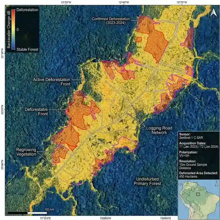
When a forest is intact, the radar energy, particularly in the L-band and C-band, undergoes "volume scattering." The pulses bounce around multiple times among the leaves, branches, and trunks before some of the energy returns to the sensor. This multiple-bounce scattering path results in a relatively strong and distinct backscatter signal returning to the satellite antenna. But when a patch of forest is cut down, the physical structure of the area changes dramatically. The complex, three-dimensional structure of the trees is replaced by a flat, open surface, which is often just bare soil or low-lying brush.
When the radar pulse hits this newly cleared area, instead of scattering in multiple directions within a canopy, the energy tends to reflect away from the sensor, much like a mirror reflecting light. This phenomenon is known as "specular reflection." As a result of this specular reflection away from the satellite, the amount of energy returning to the sensor drops significantly. By comparing a SAR image taken before the logging event with one taken after, analysts can easily detect this dramatic decrease in backscatter. The dark patches that appear in the post-logging SAR image correspond precisely to the areas where trees have been removed, creating a highly visible scar on the radar map.
Advanced Techniques: Interferometric SAR (InSAR) and Polarimetry
Beyond simple backscatter intensity analysis, scientists use advanced techniques to extract even more comprehensive information from SAR data. One such transformative technique is Interferometric Synthetic Aperture Radar (InSAR). InSAR involves combining two or more SAR images of the same area, taken from slightly different positions or at different times. By analyzing the phase difference between the radar waves in these returning signals, scientists can measure the precise distance from the satellite to the ground target. This allows for the creation of highly accurate digital elevation models (DEMs) and the detection of minute changes in the Earth's surface down to the millimeter scale. In forestry, InSAR can be leveraged to estimate tree height and forest biomass, providing a vital three-dimensional perspective on forest health and carbon stock estimations.
Another highly capable technique is SAR Polarimetry (PolSAR). Radar waves can be polarized, meaning the electromagnetic wave oscillates in a specific orientation, typically horizontal or vertical. A fully polarimetric SAR system transmits and receives radar pulses in multiple polarizations (Horizontal-Horizontal, Vertical-Vertical, Horizontal-Vertical, Vertical-Horizontal). Different physical structures reflect different polarizations in unique and characteristic ways.
For example, a vertical tree trunk will reflect radar energy differently than a horizontal branch or a flat, smooth ground surface. By analyzing the complex polarimetric signatures and decomposing the scattering mechanisms, scientists can classify forest types, estimate biomass more accurately, and distinguish between different types of land cover changes with remarkable precision, separating natural windfall from human-induced clear-cutting.
Key Satellite Missions Powering Deforestation Monitoring
The ability to monitor global deforestation using SAR has been made possible by a series of highly sophisticated satellite missions launched by various space agencies around the world. These missions provide the continuous stream of data necessary to power global monitoring platforms, enabling an unparalleled era of planetary transparency.
Sentinel-1 (European Space Agency)
The Copernicus Sentinel-1 mission, operated by the European Space Agency (ESA), has revolutionized the field of SAR remote sensing. Consisting of a constellation of satellites, the mission provides continuous, high-resolution C-band SAR imagery of the entire globe. One of the most significant and paradigm-shifting aspects of the Sentinel-1 mission is its open data policy. The imagery is freely available to researchers, NGOs, and the public without restrictive licensing fees, democratizing access to high-quality SAR data. With a revisit time of just a few days over many parts of the world, Sentinel-1 provides an unparalleled capability for the rapid detection of deforestation events, serving as the backbone for many contemporary early warning systems.
ALOS PALSAR and ALOS-2 (JAXA)
The Advanced Land Observing Satellite (ALOS) missions, operated by the Japan Aerospace Exploration Agency (JAXA), have been absolutely instrumental in forestry applications. ALOS carried the PALSAR instrument, and its successor ALOS-2 carries PALSAR-2, both of which are advanced L-band SAR systems. As previously mentioned, L-band radar is uniquely suited for forest monitoring due to its enhanced ability to penetrate the forest canopy and interact with woody biomass. JAXA's L-band data has been crucial for mapping global forest biomass, defining the world's carbon sinks, and detecting deforestation in dense tropical regions where shorter-wavelength C-band signals might struggle to penetrate deeply enough to capture understory changes.
NISAR (NASA and ISRO)
One of the most highly anticipated upcoming missions is the NASA-ISRO SAR (NISAR) mission, a groundbreaking collaborative effort between the United States and India. NISAR will be the first satellite mission to utilize two different radar frequencies (L-band and S-band) simultaneously on a single platform. This dual-frequency capability, combined with a highly advanced deployable mesh reflector antenna, will allow NISAR to observe the Earth with unparalleled detail and coverage. For forest monitoring, NISAR is expected to provide transformative insights into forest biomass, ecosystem dynamics, and high-resolution carbon mapping. Its continuous, globally consistent data will be critical for understanding how forests respond to climate change and human intervention on a massive scale, setting a new gold standard for Earth observation.
Tracking Illegal Logging: From Space to the Ground
The practical application of monitoring deforestation using synthetic aperture radar involves translating complex satellite data into actionable intelligence on the ground. This process requires a sophisticated combination of automated algorithms, machine learning, and rapid dissemination networks to ensure that the data actually leads to conservation outcomes.
Automated Detection Algorithms
Given the massive volume of data generated by satellite constellations like Sentinel-1, which produce terabytes of imagery daily, it is physically impossible for human analysts to manually inspect every image for signs of deforestation. Instead, computer scientists and remote sensing experts have developed sophisticated automated algorithms to process the data in near-real-time. These algorithms continuously analyze the incoming stream of SAR images, comparing the latest image of a specific area with a carefully constructed historical baseline that accounts for natural seasonal variations. When the algorithm detects a sudden and statistically significant drop in radar backscatter, indicative of structural canopy loss and tree removal, it automatically flags the area as a potential deforestation event.
Machine Learning and Artificial Intelligence
The integration of machine learning and Artificial Intelligence (AI) has dramatically improved the accuracy, scalability, and efficiency of these detection systems. Machine learning models, such as Convolutional Neural Networks (CNNs), are trained on vast datasets of historical SAR imagery where deforestation events have been definitively confirmed by field data or high-resolution optical imagery. By "learning" the specific and subtle radar signatures associated with different types of forest clearing (e.g., distinguishing selective logging trails from large-scale clear-cutting for agriculture), these AI models can drastically reduce the number of false positives. They can also learn to distinguish between actual deforestation and natural environmental changes in the forest, such as seasonal leaf-drop in deciduous forests or temporary flood events, which can also alter radar backscatter but do not represent permanent forest loss.
Early Warning Systems and Law Enforcement
The ultimate goal of tracking illegal logging with SAR is to provide an operational early warning system that enables rapid, on-the-ground intervention. Platforms like Global Forest Watch and national forest monitoring agencies have integrated SAR-based detection algorithms to generate automated, near-real-time alerts. When a potential illegal logging event is detected by the algorithms, an alert containing precise geographic coordinates and temporal data is automatically sent directly to local authorities, park rangers, and allied conservation organizations via mobile applications and dashboards. Because SAR can penetrate persistent clouds and operate at night, these alerts can be generated within days, or sometimes even hours, of the logging taking place.
This rapid turnaround time is a complete major advancement for environmental law enforcement. Instead of discovering a massive, barren clear-cut months after the fact during a routine patrol or via a delayed optical image, rangers can be dispatched immediately to the exact GPS coordinates of an active logging operation while the perpetrators are still on site. This allows for the critical confiscation of heavy machinery, the immediate arrest of the loggers, and most importantly, the prevention of further contiguous destruction. The sheer knowledge among criminal networks that these unblinking "eyes in the sky" can see through the clouds and operate continuously acts as a powerful psychological and practical deterrent to illegal logging syndicates.
Challenges and Limitations of SAR in Forest Monitoring
While monitoring deforestation using synthetic aperture radar is highly capable and represents the cutting edge of conservation technology, it is not without its technical challenges and physical limitations. Understanding these limitations is absolutely crucial for interpreting the data correctly, avoiding misclassification, and developing robust, multi-sensor monitoring systems.
Data Complexity and Processing Power
One of the primary challenges is the sheer complexity of SAR data itself. Unlike optical imagery, which is relatively straightforward to interpret visually because it mimics human sight, SAR images can look like random, grainy black-and-white noise to the untrained eye due to a phenomenon called "speckle." Interpreting the phase and amplitude of microwave backscatter requires highly specialized knowledge in radar physics, electromagnetics, and complex digital signal processing. Also, processing large volumes of SAR data, especially performing interferometric or polarimetric analyses, requires significant computational power, specialized software, and massive data storage capabilities. This technical barrier to entry can hinder the adoption of SAR technology by smaller conservation organizations and resource-constrained developing nations.
Topographic Distortions
Because SAR is inherently a side-looking radar system, the topography of the Earth's surface can significantly distort the resulting images in complex ways. In mountainous or highly rugged terrain, the radar pulses interact with the slopes in ways that create geometric distortions. These include "layover" (where the top of a mountain appears closer to the sensor than the bottom, causing the image to fold over on itself) and "radar shadow" (where the area behind a mountain or steep hill is completely hidden from the sensor's view). These severe topographic effects can make it very difficult to accurately measure forest change in mountainous regions without applying complex, compute-intensive radiometric and geometric terrain corrections using high-resolution digital elevation models.
Environmental Noise: Soil Moisture and Inundation
Although SAR penetrates clouds with ease, the microwave radar signal is highly sensitive to changes in moisture on the ground and within the vegetation canopy. A sudden, heavy tropical downpour can dramatically alter the soil moisture content or cause localized flooding under the forest canopy. Because liquid water reflects radar energy very differently than dry soil or vegetation, these rapid changes in environmental moisture can cause large fluctuations in the backscatter signal that look confusingly similar to deforestation signatures. Distinguishing between a real, permanent deforestation event and a temporary, reversible change in soil moisture or seasonal inundation remains a significant challenge, requiring advanced time-series analysis techniques and the integration of auxiliary meteorological and hydrological data.
Selective Logging Detection
While SAR is extraordinarily excellent at detecting large-scale clear-cutting and the creation of new agricultural frontiers, it struggles considerably to detect selective logging. Selective logging is the practice of removing only a few high-value timber trees per hectare (such as mahogany or teak) while leaving the majority of the forest canopy intact. Because the overall, macroscopic canopy structure remains largely undisturbed, the corresponding change in radar backscatter is often far too subtle to be reliably detected against the background noise, especially with shorter-wavelength C-band and X-band systems. Detecting the tiny gaps and logging trails associated with selective logging typically requires ultra-high-resolution L-band or P-band SAR, often combined with advanced interferometric or polarimetric techniques, and this remains a highly active, challenging area of ongoing scientific research.
Future Perspectives: The Next Generation of Forest Monitoring
Despite these technical challenges, the future of monitoring deforestation using synthetic aperture radar is incredibly bright and filled with technological promise. The global remote sensing community is continually innovating, developing new generations of sensors, pioneering advanced AI algorithms, and building collaborative, cloud-based platforms that will further revolutionize our ability to protect global forests.
One of the most exciting and disruptive developments in the industry is the rapid rise of commercial SAR constellations. Companies like ICEYE, Capella Space, and Umbra are deploying massive networks of small, relatively inexpensive, yet highly capable SAR satellites. These micro-satellites can revisit the exact same location on Earth multiple times a single day. This unparalleled high-frequency temporal resolution will allow for genuine near-real-time monitoring of high-risk conservation areas, enabling law enforcement and rangers to respond to illegal logging incursions almost instantly, shifting the paradigm from reaction to prevention.
Also, the integration of SAR data with other distinct remote sensing modalities is becoming increasingly common and sophisticated. By intelligently combining the all-weather, canopy-penetrating structural capabilities of SAR with the detailed chemical and spectral information provided by optical sensors like Sentinel-2, and the ultra-precise 3D structural mapping provided by LiDAR (Light Detection and Ranging), scientists can create a comprehensive, multi-layered "digital twin" of the forest ecosystem. This synergistic approach, often referred to as multi-sensor data fusion, allows for far more accurate, robust, and nuanced forest monitoring than any single technology could possibly achieve on its own.
Finally, cloud computing platforms, such as Google Earth Engine, Microsoft Planetary Computer, and Amazon Web Services, have fundamentally revolutionized the field by providing researchers with unparalleled, frictionless access to massive petabyte-scale archives of satellite data and the supercomputing resources needed to process them instantly. This profound democratization of data access and processing power ensures that scientists, local governments, and indigenous conservationists all over the world, regardless of their local computing infrastructure or financial resources, can leverage the immense power of SAR to protect their local ecosystems and monitor their ancestral lands.
Conclusion
The fight to preserve the world's remaining forests is a desperate race against time and an escalating global crisis. As climate change accelerates, biodiversity plummets, and the insatiable economic demand for natural resources grows, the pressure on these fragile, indispensable ecosystems will only intensify. In this complex and ongoing struggle, advanced technology is arguably our most potent weapon, and monitoring deforestation using synthetic aperture radar stands firmly at the absolute forefront of our planetary defense strategy.
SAR technology has fundamentally and irreversibly transformed our entire approach to environmental conservation and forest management. By effortlessly piercing through the dense, persistent cloud cover that shrouds the tropical belt, operating flawlessly in the pitch black of night, and providing deep, structural insights into the physical architecture of the forest itself, SAR provides a continuous, unblinking, and incorruptible eye on the world's most vulnerable and remote regions. It has dragged the illicit activities of illegal logging out of the shadows and provided sovereign governments, international NGOs, and local communities with the precise, actionable intelligence needed to enforce environmental law, prosecute offenders, and protect our shared natural heritage.
While undeniable technical challenges remain in complex data processing, accurate topographic correction, and the elusive detection of subtle selective logging practices, the incredibly rapid advancement of satellite technology, sophisticated machine learning algorithms, and accessible cloud computing platforms ensures that our global monitoring capabilities will only continue to improve at an exponential rate. As we look forward to the future, with revolutionary new public missions like NISAR on the immediate horizon and agile commercial SAR constellations multiplying in orbit, we can be highly confident that Synthetic Aperture Radar will play an increasingly vital, indispensable role in securing a sustainable, thriving future for the Earth's critical forests. Through sustained financial investment, dedicated international scientific collaboration, and an unwavering commitment to open data sharing, humanity can fully harness the extraordinary power of SAR to ensure that the vital lungs of our planet continue to breathe vibrantly for countless generations to come.
Frequently Asked Questions
Why use Synthetic Aperture Radar (SAR) for deforestation?
SAR sensors, such as those on Sentinel-1, can penetrate dense cloud cover and operate day or night. This is crucial for tropical rainforests, which are often obscured by clouds year-round.
How does SAR detect changes in forest cover?
SAR measures the 'backscatter' or radar signal returning from the Earth's surface. Tall, dense forest canopies reflect signals differently (volume scattering) than clear-cut land (surface scattering), making deforestation easily detectable.
What is L-band radar and why is it important for forestry?
L-band radar has longer wavelengths that penetrate deeper into the forest canopy, allowing it to interact directly with tree trunks and branches, making it highly accurate for measuring forest biomass and structure.
