Drone Lidar Mapping Applications in Forestry
Table of Contents
- The Technological Ecosystem of UAV LiDAR in Forestry
- Digital Terrain Modeling (DTM) and Canopy Height Modeling (CHM)
- Forest Health Monitoring and Disease Detection
- Advanced Analytics and AI Integration
- Case Studies: Transformative Implementations
- Cost-Benefit Analysis of Drone LiDAR
- The Future Trajectory of LiDAR in Forestry
- Addressing the Environmental Impact
- Data Management and Standardization
- Conclusion
- Frequently Asked Questions
rsandgis.me
The integration of advanced technologies into environmental management has ushered in a new era, particularly concerning drone lidar mapping applications in forestry. As global demands for sustainable timber and climate change mitigation escalate, the necessity for highly accurate, high-resolution 3D data of forest canopies and terrain has never been more critical. Unmanned Aerial Vehicles (UAVs) equipped with Light Detection and Ranging (LiDAR) sensors offer an unparalleled solution to this challenge, providing an extraordinary level of detail that traditional photogrammetry and satellite imagery simply cannot match. This guide explores the multi-faceted utility of drone-based LiDAR in the forestry sector, examining its technological underpinnings, practical applications, economic benefits, and future potential.
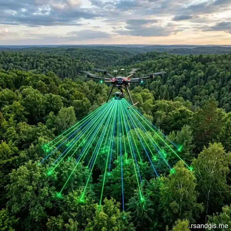
Fundamentally, LiDAR technology operates by emitting rapid pulses of laser light towards the Earth's surface and measuring the time it takes for the reflected light to return to the sensor. When mounted on a drone, this system can generate millions of data points per second, culminating in a highly dense and accurate 3D point cloud of the surveyed area. Unlike passive sensors, LiDAR is an active remote sensing technology, meaning it can operate in various lighting conditions and penetrate dense forest canopies to reach the forest floor. This penetration capability is the key differentiator, allowing for the simultaneous mapping of both the upper canopy structure and the underlying digital terrain model (DTM).
The transition from traditional manned aircraft to drones for LiDAR data acquisition has democratized access to high-quality forestry data. Manned flights are often prohibitively expensive and require large survey areas to be economically viable. In contrast, drones can be rapidly deployed for targeted, localized surveys at a fraction of the cost. This flexibility enables forest managers to conduct frequent, high-resolution assessments of dynamic environments, such as monitoring the immediate aftermath of a natural disaster or tracking the rapid growth of newly planted saplings. The localized control also ensures that data can be captured under optimal weather conditions, reducing the risk of cloud cover interference that plagues satellite imagery.
The Technological Ecosystem of UAV LiDAR in Forestry
Understanding the full scope of drone lidar mapping applications in forestry requires a deep dive into the underlying technological ecosystem. A standard drone LiDAR setup is not merely a flying laser; it is a complex integration of several highly sophisticated components working in unison. The primary sensor, the laser scanner, is complemented by a Global Navigation Satellite System (GNSS) receiver and an Inertial Measurement Unit (IMU). The GNSS provides the absolute geographical coordinates of the drone, while the IMU meticulously tracks the drone's pitch, roll, and yaw at hundreds of times per second. This precise spatial and orientation data is crucial for accurately geo-referencing every single laser pulse reflected from the forest.
The choice of laser wavelength is particularly important in forestry applications. Most topographical LiDAR systems operate in the near-infrared spectrum (typically around 905 nm or 1064 nm), as these wavelengths are strongly reflected by vegetation. But for specialized applications such as mapping riparian zones or coastal mangroves, bathymetric LiDAR systems utilizing green lasers (532 nm) may be employed, as they can penetrate the water column to map the underlying topography. The pulse repetition rate and the number of returns per pulse also significantly impact the quality of the data. Advanced systems can record multiple returns from a single pulse, allowing for the differentiation between the top of the canopy, intermediate branches, and the bare earth.
Also, the physical drone platform itself plays a vital role. Multi-rotor drones offer exceptional maneuverability and the ability to hover, making them ideal for small, complex survey areas. Conversely, fixed-wing or VTOL (Vertical Take-Off and Landing) drones provide longer flight times and can cover vast tracts of forest in a single mission. The payload capacity of the drone dictates the type of LiDAR sensor that can be carried, with heavier, more powerful sensors generally offering higher point densities and greater accuracy. The seamless integration of these hardware components with advanced flight planning software ensures that the drone follows a precise trajectory, maintaining optimal overlap between flight lines to eliminate data gaps.
Digital Terrain Modeling (DTM) and Canopy Height Modeling (CHM)
One of the most foundational drone lidar mapping applications in forestry is the creation of highly accurate Digital Terrain Models (DTMs). Traditional photogrammetry struggles to map the forest floor because the canopy blocks the line of sight. LiDAR, however, can penetrate the small gaps in the foliage, allowing a percentage of the laser pulses to reach the ground. By filtering the resulting point cloud to isolate these ground returns, software algorithms can interpolate a continuous 3D model of the bare earth. This DTM is invaluable for planning logging roads, designing drainage systems, and assessing topographical features that influence water flow and soil erosion.
Building upon the DTM, foresters can generate Canopy Height Models (CHMs). A CHM is created by subtracting the elevation of the DTM from the Digital Surface Model (DSM), which represents the uppermost surface of the canopy. The resulting model provides a precise measurement of tree height across the entire survey area. This is a critical parameter for estimating timber volume, assessing forest health, and classifying different stand types. The high resolution of drone-derived CHMs allows for the identification of individual tree crowns (ITC), a task that was previously labor-intensive or entirely impossible with lower-resolution data sources.
The ability to isolate individual trees opens up a wealth of analytical possibilities. Advanced segmentation algorithms can analyze the shape and structure of each identified crown to determine the species, calculate the crown diameter, and estimate the total above-ground biomass. This level of granularity is transforming forest inventory processes. Instead of relying on statistical sampling from a few small field plots, forest managers can now obtain a comprehensive, tree-by-tree census of their entire holding. This transition from sample-based estimation to direct measurement drastically reduces uncertainty and allows for highly optimized harvesting strategies.

Forest Health Monitoring and Disease Detection
Beyond structural measurements, drone lidar mapping applications in forestry extend to monitoring the overall health and vitality of the ecosystem. Changes in canopy structure can be early indicators of stress caused by drought, disease, or insect infestations.
For instance, defoliation caused by pests like the mountain pine beetle or the emerald ash borer results in a distinct change in the density and distribution of LiDAR returns. By conducting multi-temporal LiDAR surveys, comparing point clouds from different time periods, foresters can detect these subtle structural changes long before they become visually apparent in traditional optical imagery.
Also, when LiDAR is combined with other drone-based sensors, such as multispectral or hyperspectral cameras, the analytical capabilities are exponentially enhanced. The LiDAR provides the structural context (the 3D framework of the tree), while the spectral sensors provide biochemical information about the foliage (such as chlorophyll content or water stress). This synergistic approach allows for the precise localization of diseased trees within the 3D canopy structure.
For example, a hyperspectral sensor might identify a tree with a declining photosynthetic rate, and the LiDAR data can precisely pinpoint its location, height, and volume, enabling targeted interventions such as localized pesticide application or selective removal.
The assessment of forest fire risk is another critical health-related application. Wildfires require fuel to spread, and the structural arrangement of that fuel is a key determinant of fire behavior. Drone LiDAR can precisely map the vertical distribution of vegetation, from the ground-level brush (surface fuels) to the intermediate saplings and lower branches (ladder fuels) that can carry a fire up into the main canopy. By quantifying these different fuel strata, fire ecologists can create highly detailed fire behavior models, identify high-risk areas, and plan strategic prescribed burns or mechanical thinning operations to mitigate the danger.
Advanced Analytics and AI Integration
The massive volume of data generated by drone LiDAR necessitates advanced analytical tools. Manual interpretation of point clouds containing hundreds of millions of points is simply not feasible. As a result, the integration of Artificial Intelligence (AI) and Machine Learning (ML) algorithms is rapidly becoming a standard component of drone lidar mapping applications in forestry. Deep learning models, particularly 3D Convolutional Neural Networks (CNNs), are being trained to automatically classify LiDAR points into different categories, such as ground, vegetation, buildings, and water bodies.
These AI algorithms excel at recognizing complex spatial patterns within the point cloud.
For instance, they can be trained to identify specific tree species based on the unique structural signature of their branching patterns and crown architecture. This automated species classification is a massive leap forward for biodiversity assessments and mixed-forest management. Also, AI can automate the extraction of critical forestry metrics, such as the Diameter at Breast Height (DBH), by analyzing the lower sections of the point cloud where the tree trunks are visible. This level of automation significantly reduces the time and cost associated with data processing, turning raw point clouds into actionable insights in a matter of hours rather than weeks.
The use of AI also extends to predictive modeling. By combining LiDAR-derived structural data with environmental variables (such as soil type, climate, and topography), ML algorithms can predict future forest growth, yield, and carbon sequestration potential with unparalleled accuracy. These predictive models are essential for long-term strategic planning, helping forestry companies optimize their rotation cycles and ensure the sustainable management of their resources. They also is essential in the growing carbon credit market, providing the rigorous, verifiable data required to quantify the amount of carbon stored in a specific forest stand.
Case Studies: Transformative Implementations
To truly appreciate the impact of these technologies, it is instructive to examine real-world case studies. In the Pacific Northwest, large timber companies are utilizing drone LiDAR to plan complex harvesting operations in steep, mountainous terrain. Traditional planning methods were slow and dangerous, requiring surveyors to physically traverse the difficult landscape. Now, a single drone flight can provide a highly detailed DTM, allowing engineers to design optimal cable yarding corridors and logging roads from the safety of an office, significantly reducing operational costs and improving worker safety.
In tropical rainforests, researchers are using drone LiDAR to map the complex, multi-layered canopy structures that are vital for biodiversity. These environments are notoriously difficult to survey from the ground due to the dense undergrowth and challenging logistics. Drone LiDAR allows researchers to quantify the structural diversity of the canopy, identify emergent trees, and map the distribution of critical habitats for endangered species. This data is invaluable for conservation planning and for monitoring the impact of selective logging operations on the overall ecosystem structure.
Also, in urban forestry, municipalities are deploying drone LiDAR to manage the urban canopy. Trees in urban environments provide crucial benefits, such as reducing the heat island effect and improving air quality. But they also require careful management to prevent conflicts with infrastructure, such as power lines and buildings. Drone LiDAR provides a precise 3D map of the urban forest, allowing city planners to monitor tree growth, identify hazardous trees, and optimize pruning schedules. The high resolution of the data ensures that individual trees can be tracked over time, providing a comprehensive inventory of the city's green assets.
Cost-Benefit Analysis of Drone LiDAR
While the initial capital investment in a high-quality drone LiDAR system can be substantial, the long-term cost-benefit analysis heavily favors its adoption. The primary savings stem from the dramatic reduction in manual field labor. Traditional forest cruising is incredibly time-consuming and labor-intensive, requiring teams of surveyors to measure trees by hand. Drone LiDAR can cover in an hour what would take a ground crew days or even weeks to measure. This increased efficiency translates directly into lower operational costs and faster turnaround times for critical data.
Plus, the sheer accuracy and density of the LiDAR data provide indirect economic benefits. More precise timber volume estimates allow for better negotiation with buyers and optimized harvest planning, minimizing waste and maximizing yield. The ability to quickly identify and address forest health issues can prevent large-scale losses due to disease or pests. Also, the detailed DTMs enable more efficient road design, reducing earthmoving costs and minimizing environmental impact. When all these factors are considered, the Return on Investment (ROI) for drone LiDAR in commercial forestry is exceptionally compelling.
The Future Trajectory of LiDAR in Forestry
Looking ahead, the trajectory of drone lidar mapping applications in forestry points toward even greater integration and miniaturization. As sensor technology continues to advance, we can expect LiDAR systems to become lighter, more powerful, and less expensive. This will enable the use of smaller, more agile drones, further reducing operational barriers and expanding the potential use cases. The development of Solid-State LiDAR, which eliminates the moving mechanical parts of traditional scanners, promises to dramatically increase reliability and reduce costs, potentially making LiDAR a standard sensor on almost all commercial forestry drones.
Also, the concept of swarm robotics is likely to play a significant role in the future. Instead of a single drone conducting a survey, a coordinated swarm of autonomous drones could rapidly map vast areas of forest, dynamically adjusting their flight paths based on real-time data analysis. This approach would dramatically increase the speed and scalability of data acquisition, making it feasible to conduct continent-scale high-resolution forest inventories. The data processing will also become increasingly automated, with cloud-based AI platforms instantly analyzing the point clouds as they are uploaded, providing forest managers with real-time, actionable insights directly to their mobile devices.
Addressing the Environmental Impact
It is also essential to consider the environmental impact of utilizing this technology. Compared to traditional manned aircraft or heavy ground-based surveying equipment, drones have a remarkably small carbon footprint. They are typically battery-powered, resulting in zero direct emissions during flight. The noise pollution is also significantly lower, minimizing disturbance to wildlife in sensitive ecological areas. Also, by providing the data necessary for highly optimized, precision forestry, drone LiDAR actively contributes to more sustainable land management practices, reducing unnecessary soil compaction and minimizing the overall environmental footprint of harvesting operations.
Data Management and Standardization
As the adoption of drone LiDAR accelerates, the industry must also address the challenges associated with data management and standardization. The massive point clouds generated by these systems require substantial storage and processing power. Organizations must implement robust data management strategies to ensure that the data is securely stored, easily accessible, and properly cataloged. Also, there is a pressing need for industry-wide standards regarding data formats, metadata requirements, and accuracy reporting. Standardization will facilitate the sharing of data between different stakeholders, enable the development of interoperable software tools, and ensure the long-term viability of the data for longitudinal studies.
Conclusion
Ultimately, the advent of drone lidar mapping applications in forestry represents a fundamental major shift in how we understand and manage our natural resources. By providing an unparalleled 3D perspective of the forest structure, from the highest canopy peaks to the underlying terrain, LiDAR is replacing estimation with precise measurement. This technological revolution is driving improvements in efficiency, safety, and sustainability across the entire forestry sector. As the hardware becomes more accessible and the AI-driven analytics become more sophisticated, drone LiDAR will undoubtedly solidify its position as an indispensable tool for the modern forester, ensuring the responsible stewardship of our global forests for generations to come.
To elaborate further on the specifics of point cloud classification, the process involves sophisticated filtering algorithms that iteratively separate ground hits from above-ground features. One common approach is the progressive morphological filter, which gradually increases a window size to identify and remove points that fall above a certain elevation threshold relative to their neighbors. This algorithm is particularly effective in forested environments with steep slopes and complex terrain. Once the ground points are isolated, the remaining points are typically classified into various vegetation strata, allowing for a detailed analysis of the understory, midstory, and overstory structures. This multi-layered perspective is crucial for understanding the complex ecological dynamics of the forest and for planning interventions that promote structural diversity.
Another critical area of development is the fusion of drone LiDAR with terrestrial laser scanning (TLS). While drone LiDAR provides excellent coverage of the upper canopy and the terrain, it can sometimes struggle to capture the intricate details of the lower tree trunks and the understory vegetation due to occlusion from the upper branches. TLS, on the other hand, provides incredibly dense data from the ground up, capturing the precise geometry of the stems and lower branches. By co-registering the drone LiDAR point cloud with the TLS point cloud, foresters can create a truly comprehensive 3D model of the forest, combining the broad spatial coverage of the drone with the high-fidelity detail of the terrestrial scanner. This fused dataset is invaluable for highly detailed biomass estimations, stem quality assessments, and complex ecological modeling.
The regulatory landscape surrounding commercial drone operations is also a significant factor influencing the adoption of this technology. In many jurisdictions, regulations dictate maximum flight altitudes, visual line of sight (VLOS) requirements, and restrictions on flying over populated areas. But as drone technology matures and sense-and-avoid systems become more reliable, aviation authorities are increasingly granting waivers for beyond visual line of sight (BVLOS) operations. The ability to fly BVLOS will be a major catalyst for drone LiDAR in forestry, allowing a single operator to survey massive, remote tracts of land without the need for constant visual contact with the aircraft. This regulatory evolution, coupled with continuous technological advancements, will undoubtedly accelerate the integration of drone LiDAR into mainstream forestry practices worldwide.
To elaborate further on the specifics of point cloud classification, the process involves sophisticated filtering algorithms that iteratively separate ground hits from above-ground features. One common approach is the progressive morphological filter, which gradually increases a window size to identify and remove points that fall above a certain elevation threshold relative to their neighbors. This algorithm is particularly effective in forested environments with steep slopes and complex terrain. Once the ground points are isolated, the remaining points are typically classified into various vegetation strata, allowing for a detailed analysis of the understory, midstory, and overstory structures. This multi-layered perspective is crucial for understanding the complex ecological dynamics of the forest and for planning interventions that promote structural diversity.
Another critical area of development is the fusion of drone LiDAR with terrestrial laser scanning (TLS). While drone LiDAR provides excellent coverage of the upper canopy and the terrain, it can sometimes struggle to capture the intricate details of the lower tree trunks and the understory vegetation due to occlusion from the upper branches. TLS, on the other hand, provides incredibly dense data from the ground up, capturing the precise geometry of the stems and lower branches. By co-registering the drone LiDAR point cloud with the TLS point cloud, foresters can create a truly comprehensive 3D model of the forest, combining the broad spatial coverage of the drone with the high-fidelity detail of the terrestrial scanner. This fused dataset is invaluable for highly detailed biomass estimations, stem quality assessments, and complex ecological modeling.
The regulatory landscape surrounding commercial drone operations is also a significant factor influencing the adoption of this technology. In many jurisdictions, regulations dictate maximum flight altitudes, visual line of sight (VLOS) requirements, and restrictions on flying over populated areas. But as drone technology matures and sense-and-avoid systems become more reliable, aviation authorities are increasingly granting waivers for beyond visual line of sight (BVLOS) operations. The ability to fly BVLOS will be a major catalyst for drone LiDAR in forestry, allowing a single operator to survey massive, remote tracts of land without the need for constant visual contact with the aircraft. This regulatory evolution, coupled with continuous technological advancements, will undoubtedly accelerate the integration of drone LiDAR into mainstream forestry practices worldwide.
Frequently Asked Questions
How is LiDAR used in forestry?
LiDAR in forestry is used to penetrate the forest canopy using laser pulses, creating highly accurate 3D point clouds that measure tree height, crown diameter, and understory topography.
What is the advantage of drone LiDAR over satellite imagery?
Drone LiDAR provides significantly higher point density and can penetrate dense foliage to map the bare earth below, which passive optical satellite imagery cannot do.
What is a Digital Terrain Model (DTM) in forestry?
A DTM is a bare-earth 3D representation of the terrain created by filtering out vegetation and man-made structures from LiDAR point clouds, essential for hydrological modeling and harvest planning.
