Introduction to the Spatial Data Revolution
Table of Contents
- What is Spatial Data?
- The Growing Demand for Spatial Professionals
- The Core Career Paths in Spatial Data
- GIS Analyst vs. GIS Specialist
- Remote Sensing Jobs and Imagery Analysis
- The Rise of Geospatial Data Scientists and Developers
- Essential Skills to Land GIS Jobs and Remote Sensing Jobs
- Mastering Foundational GIS Software
- Advanced Remote Sensing and Image Processing Tools
- The Crucial Role of Programming: Python, SQL, and R
- Web Mapping and Cloud Native GIS
- Education, GIS Certificates, and Certifications
- University Degrees: Bachelor’s to PhD
- Should You Get a GIS Certificate?
- Professional Certifications: GISP and Vendor-Specific Badges
- Salary Expectations and Career Trajectory
- Entry-Level: Avoiding the Technician Trap
- Mid-Career: Becoming a GIS Analyst or GIS Specialist
- Senior Level: Management and Geospatial Architecture
- Building a Standout Spatial Data Portfolio
- Creating Real-World Projects
- Contributing to Open Source and Open Data
- Navigating the Job Market and Soft Skills
- The Importance of Soft Skills
- Industries Hiring for GIS and Remote Sensing Jobs
- Networking and Hidden Job Markets
- The Future of Spatial Data Careers
- AI, Machine Learning, and Autonomous Drones
- Conclusion: Your Roadmap to Success
- Frequently Asked Questions
rsandgis.me
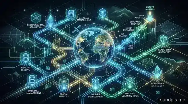
The world is increasingly driven by "where" things happen. From global logistics and urban planning to environmental conservation, disaster response, and precision agriculture, the integration of location intelligence into business and government operations has triggered a massive spatial data revolution. If you are passionate about geography, technology, and analytical problem-solving, building a career in spatial data—specifically targeting GIS jobs and remote sensing jobs—offers a future-proof trajectory. In this comprehensive guide, we will break down the essential steps to launch, navigate, and accelerate your geospatial career, taking you from a beginner to an in-demand spatial professional.
What is Spatial Data?
Spatial data, or geospatial data, refers to any information that has a geographic aspect or location coordinate associated with it. This data comes in two primary forms:
- Vector Data: This format uses discrete points, lines, and polygons to represent real-world features. Think of fire hydrants (points), highway networks (lines), or county boundaries (polygons). Vector data is highly precise and is typically used for administrative, network, and parcel mapping.
- Raster Data: This format uses grids of pixels, where each pixel contains a value representing information. Satellite imagery, aerial photographs, digital elevation models (DEMs), and land cover classifications are classic examples of raster data. It is ideal for continuous phenomena like temperature or elevation.
The professionals who manipulate, analyze, and visualize this data use Geographic Information Systems (GIS) and remote sensing technology to uncover spatial patterns, trends, and relationships that are completely invisible on a standard spreadsheet.
The Growing Demand for Spatial Professionals
The demand for spatial data experts is skyrocketing globally. As organizations collect vast amounts of location-based data from mobile devices, IoT (Internet of Things) sensors, drones, and a growing constellation of earth observation satellites, they are overwhelmed by data. They desperately need skilled individuals to make sense of it all. Whether it is tracking the spread of a global pandemic, optimizing complex supply chain delivery routes, or monitoring deforestation in the Amazon from space, the skills of a GIS analyst or remote sensing expert are critical. This demand spans across both the public and private sectors, making geospatial science one of the most versatile, impactful, and resilient career paths available today.
The Core Career Paths in Spatial Data
The spatial data industry is broad, and job titles can sometimes be ambiguous or overlap. Understanding the nuances between different roles is crucial for mapping out your career trajectory and focusing your skill development. Here is a detailed look at the primary career paths you can pursue in the geospatial arena.
GIS Analyst vs. GIS Specialist
While the terms are often used interchangeably in job postings by HR departments, there are distinct, recognized differences between a GIS analyst and a GIS specialist in the professional geospatial community.
A GIS analyst primarily focuses on data analysis, statistical modeling, and interpretation. Their day-to-day work involves taking spatial and non-spatial data, running complex geoprocessing queries, performing spatial modeling (like suitability analysis or network routing), and creating visualizations (such as production-quality maps or interactive dashboards) to answer specific business, environmental, or research questions. An analyst is essentially a problem solver who uses GIS as their primary analytical tool. They need a deep understanding of spatial statistics, geography, and cartographic design.
On the other hand, a GIS specialist tends to focus more on the technical infrastructure, data architecture, system administration, and workflow optimization. A specialist might be responsible for designing complex enterprise geodatabases, managing GIS servers (like ArcGIS Enterprise or GeoServer), ensuring data quality and topological integrity, and supporting other staff members who use GIS software. They often have stronger IT, database administration, and systems engineering skills compared to analysts.
Remote Sensing Jobs and Imagery Analysis
Remote sensing jobs focus specifically on the acquisition, processing, and analysis of imagery captured from a distance—usually via satellites (like Landsat, Sentinel, or commercial constellations like Planet), aircraft, or unmanned aerial vehicles (drones). While GIS is about managing and analyzing spatial data in general, remote sensing is a specialized, highly technical sub-field dealing almost exclusively with raster data and multispectral imagery.
Professionals in these roles use specialized algorithms to process images, perform atmospheric and radiometric corrections, and extract meaningful information from different bands of the electromagnetic spectrum. For example, a remote sensing analyst might use near-infrared imagery to assess crop health by calculating the Normalized Difference Vegetation Index (NDVI), use LiDAR (Light Detection and Ranging) point clouds to create highly accurate 3D elevation models for flood risk assessment, or analyze synthetic aperture radar (SAR) data to monitor ground subsidence and soil moisture. If you love working with imagery, physics, and understanding the physical properties of the earth's surface, this path is highly rewarding and often commands a premium salary.
The Rise of Geospatial Data Scientists and Developers
As the spatial industry matures, there is a rapidly growing overlap with traditional computer science, software engineering, and data science.
- GIS Developers: These professionals focus on building custom web mapping applications, automating enterprise workflows, creating new GIS software tools, and integrating spatial capabilities into broader IT systems. They spend most of their time writing code rather than clicking through desktop GIS interfaces.
- Geospatial Data Scientists: This is a multidisciplinary role that combines big data analytics, machine learning, and artificial intelligence with traditional spatial principles. They process massive, petabyte-scale datasets that traditional GIS software cannot handle, often working in cloud environments to predict spatial phenomena.
These technical roles represent the upper echelon of the profession in terms of technical skill, impact, and salary potential.
Essential Skills to Land GIS Jobs and Remote Sensing Jobs
To succeed in the modern geospatial landscape, you must build a robust, multi-disciplinary technical toolkit. Gone are the days when simply knowing how to click buttons in a desktop mapping software (a "point-and-clicker") was enough to guarantee a long-term career. Today’s employers are looking for a blend of domain knowledge, software proficiency, and programming acumen.
Mastering Foundational GIS Software
Your journey begins with mastering the core GIS platforms. The industry is largely divided into two primary ecosystems, and knowing both makes you highly competitive:
- Esri ArcGIS: The undisputed commercial industry standard. Proficiency in ArcGIS Pro (the modern desktop application), ArcGIS Online (AGOL, the cloud platform), and ArcGIS Enterprise is required for the vast majority of government, defense, and corporate GIS jobs.
- QGIS: The leading open-source GIS software. It is incredibly powerful, widely used in academia, research, NGOs, and tech startups, and serves as an excellent platform to learn spatial concepts without expensive licensing fees. QGIS integrates seamlessly with other open-source tools like GRASS and SAGA GIS.
A successful professional should be comfortable navigating both environments, understanding how to perform spatial joins, digitize features accurately, run geoprocessing tools, and create aesthetically pleasing, production-quality cartographic products.
Advanced Remote Sensing and Image Processing Tools
If you are specifically targeting remote sensing jobs, you need to go well beyond basic GIS software. You must become proficient in specialized image processing tools. Industry desktop favorites include ENVI, ERDAS IMAGINE, and Trimble eCognition (which is the gold standard for Object-Based Image Analysis, or OBIA).
Furthermore, cloud-based platforms like Google Earth Engine (GEE) have entirely revolutionized remote sensing. GEE allows analysts to process petabytes of satellite imagery using Google's massive server infrastructure without downloading a single file. Familiarity with Google Earth Engine (using either its JavaScript or Python API) is rapidly becoming a mandatory requirement for modern remote sensing and planetary-scale analysis positions.
The Crucial Role of Programming: Python, SQL, and R
The most significant delineator between entry-level technicians and highly paid analysts or specialists is programming ability. If you want to future-proof your career, you must learn to code.
- Python: Python is the undisputed king of scripting in the spatial world. Whether you are automating repetitive data processing tasks using the ArcPy library in ArcGIS, processing open-source data with GeoPandas, Shapely, and Rasterio, or writing custom QGIS plugins, Python is absolutely essential. It allows you to turn a week-long manual, error-prone task into a five-minute, repeatable script.
- SQL (Structured Query Language): SQL is critical because enterprise spatial data lives in relational databases (like PostgreSQL with the PostGIS extension, Microsoft SQL Server, or Oracle Spatial). A GIS specialist must know how to write efficient SQL queries to retrieve, filter, aggregate, and manipulate data directly at the database level, bypassing the desktop software entirely for speed and efficiency.
- R: For rigorous statistical modeling, spatial econometrics, and spatial data science, R remains a powerful tool, particularly in academic, environmental, epidemiological, and public health sectors.
Web Mapping and Cloud Native GIS
Modern maps no longer live solely on paper or desktop screens; they live on the web and mobile devices. Understanding the basics of web development (HTML, CSS, and JavaScript) and web mapping libraries like Leaflet, Mapbox GL JS, OpenLayers, or the ArcGIS API for JavaScript is a massive advantage. Additionally, understanding cloud infrastructure (AWS, Microsoft Azure, Google Cloud Platform) and how spatial data is hosted, scaled, and served via REST APIs is increasingly important for senior technical roles.
Education, GIS Certificates, and Certifications
How do you acquire these complex skills? The educational pathway for spatial professionals is diverse, ranging from traditional university degrees to specialized bootcamps and certifications.
University Degrees: Bachelor’s to PhD
The standard entry point is a bachelor’s degree in Geography, Environmental Science, Urban Planning, Computer Science, Geology, or Geomatics/Surveying. A bachelor's degree provides the foundational theories of spatial thinking, geodesy, map projections, and cartographic principles. For highly specialized roles, such as algorithm development, remote sensing research, or data science, a master's degree or PhD is often preferred or required by employers.
Should You Get a GIS Certificate?
If you already have a degree in a non-spatial field (like biology, history, public health, or business) and want to pivot into this industry, obtaining an academic GIS certificate is one of the most cost-effective and strategic moves you can make. A GIS certificate is typically offered by a university or community college (often available entirely online) and consists of 4 to 6 intensive courses focused purely on spatial technology and applied mapping.
It provides a structured learning environment, access to expensive software licenses, and networking opportunities with professors and peers without the massive time and financial commitment of a full master's degree. Crucially, a GIS certificate proves to employers that you have formal, rigorous training in spatial methodologies to complement your primary domain expertise.
Professional Certifications: GISP and Vendor-Specific Badges
It is important not to confuse an academic GIS certificate with professional certification. Professional certifications are independent validations of your on-the-job experience and competence, usually acquired after you have been working in the field for several years.
- GISP (Certified GIS Professional): Administered by the GIS Certification Institute (GISCI), earning the GISP requires a comprehensive portfolio review of your education, professional work experience, and contributions to the geospatial profession (like presenting at conferences or volunteering), followed by a rigorous core technical exam. It is highly respected in the industry and can help you stand out for management, consulting, or senior GIS specialist roles.
- Esri Technical Certifications: These exams validate your expertise in using specific Esri software products (e.g., ArcGIS Pro Foundation, Enterprise Administration, or Developer certifications). These are excellent, highly recognizable "badges" to add to your resume to instantly prove your technical chops to recruiters who might just be scanning for keywords.
- ASPRS Certifications: For remote sensing professionals, the American Society for Photogrammetry and Remote Sensing offers rigorous certifications for photogrammetrists, mapping scientists, and LiDAR specialists.
Salary Expectations and Career Trajectory
The spatial industry offers a stable and potentially lucrative career path, provided you actively manage your skill development and avoid stagnation. Salaries vary significantly based on geography, industry, and technical proficiency.
Entry-Level: Avoiding the Technician Trap
Most careers begin in entry-level roles such as GIS Technician or Junior Analyst. Technicians handle the essential but often repetitive "grunt work" of the industry: digitizing paper maps, performing data entry, QA/QC (quality assurance/quality control) checks, field data collection with GPS units, and basic map production. The salary at this level typically ranges from $40,000 to $60,000 annually in the United States.
While this is an excellent way to get your foot in the door and learn how data is actually created, beware of the dreaded "technician trap." If you do not actively spend your free time learning new, high-value skills (like Python scripting, database management, or advanced spatial analysis), you can easily get stuck doing repetitive tasks for years with very little salary growth or upward mobility.
Mid-Career: Becoming a GIS Analyst or GIS Specialist
After 2-5 years of solid experience, professionals typically transition into a GIS analyst or GIS specialist role. At this stage, you are expected to work independently, design analytical workflows, interface with stakeholders, and solve complex business problems. Salaries in the mid-career tier generally range from $65,000 to $90,000+, depending on the region and the specific industry (e.g., tech and energy sectors pay more than local government). To maximize your earning potential at this stage, focus on automating your daily workflows, learning advanced remote sensing techniques, and mastering spatial SQL.
Senior Level: Management and Geospatial Architecture
Senior professionals who transition into roles like Geospatial Architect, Enterprise GIS Manager, Geospatial Developer, or Geospatial Data Scientist see their salaries push well past $100,000, frequently exceeding $130,000 to $150,000+ in tech hubs, federal contracting, or large corporate environments. Reaching this upper echelon requires a paradigm shift: you must move from merely executing assigned tasks to driving strategic organizational goals, managing cloud computing architectures, leading teams of analysts, and directly impacting the company's bottom line through location intelligence.
Building a Standout Spatial Data Portfolio
In the spatial data industry, what you can do matters infinitely more than what you say you can do on a resume. A strong, publicly accessible portfolio is your absolute best asset when applying for competitive GIS jobs.
Creating Real-World Projects
Employers want to see that you can solve actual, messy problems, not just follow a neatly packaged textbook tutorial. Build a digital portfolio (using platforms like GitHub Pages, Esri ArcGIS StoryMaps, or a custom-built personal website) that showcases 3 to 5 highly polished projects. Where do you get data? Utilize open data portals from local governments, the USGS Earth Explorer, or the Copernicus Open Access Hub. Project ideas include:
- Site Suitability Analysis: Find the optimal location for a new solar farm based on multiple criteria: solar irradiance, slope, aspect, land use type, and distance to existing power grids and roads.
- Remote Sensing Change Detection: Use Landsat or Sentinel satellite imagery to calculate the exact acreage of deforestation in a specific region or measure the extent of urban sprawl in a rapidly growing city over a twenty-year period.
- Interactive Web Map: Build a custom dashboard that ingests and visualizes real-time data, such as local air quality sensors, live traffic incidents, or wildfire perimeters, using web mapping APIs and Python backends.
For each portfolio project, clearly explain the business or environmental problem, the raw data sources you used, the specific methodology (including any Python code, SQL queries, or models), and the final analytical results. Visuals are key—make sure your maps are beautiful and adhere to cartographic standards.
Contributing to Open Source and Open Data
Another excellent way to build your resume and gain practical experience is by contributing to the open-source community. Participate in OpenStreetMap (OSM) mapping events (mapathons) for humanitarian relief, contribute code, documentation, or bug reports to open-source software like QGIS, or answer technical questions on GIS StackExchange. These activities demonstrate your genuine passion for the field, keep your skills sharp, and help you build a global professional network.
Navigating the Job Market and Soft Skills
Knowing where to look for spatial jobs, and how to present yourself, is just as important as having the right technical skills.
The Importance of Soft Skills
While technical skills get you the interview, soft skills get you the job. Spatial professionals rarely work in isolation. You must be able to communicate complex spatial concepts to non-technical stakeholders—like city planners, business executives, or marketing teams. Being able to explain why a map matters and what action should be taken based on your analysis is the true mark of a senior professional. Project management skills (Agile, Scrum) are also increasingly highly valued.
Industries Hiring for GIS and Remote Sensing Jobs
Spatial data is ubiquitous, meaning you have the flexibility to work in almost any sector that interests you:
| Industry Sector | Typical Applications & Use Cases | Common Job Titles |
|---|---|---|
| Government & Urban Planning | Zoning enforcement, parcel mapping, emergency response routing, public works and asset management, census data analysis. | GIS Technician, GIS Analyst, City Planner |
| Environmental & Conservation | Habitat suitability modeling, watershed analysis, forestry management, climate change impact modeling, wildlife tracking. | Remote Sensing Analyst, GIS Specialist, Conservation Scientist |
| Energy, Oil & Gas, and Utilities | Pipeline routing, mineral exploration, asset management, vegetation management near power lines, renewable energy site selection. | GIS Specialist, Geospatial Developer, Data Manager |
| Agriculture & Forestry | Precision farming, crop yield prediction, soil moisture monitoring via satellites, timber yield estimation. | Remote Sensing Scientist, AgTech Data Analyst |
| Defense & Intelligence | Reconnaissance, threat analysis, logistics planning, terrain analysis, border security monitoring. | Geospatial Intelligence (GEOINT) Analyst, Imagery Analyst |
| Logistics & Retail | Supply chain optimization, fleet routing, store site selection (location intelligence), market demographic analysis. | Location Intelligence Analyst, GIS Data Scientist |
Networking and Hidden Job Markets
Many of the best geospatial positions are never posted on massive public job boards. To tap into the "hidden job market," you must network aggressively. Attend industry conferences like the Esri User Conference, FOSS4G (Free and Open Source Software for Geospatial), or local regional GIS user group meetings. Connect with recruiters and senior professionals on LinkedIn, specifically looking for titles like "GIS Manager," "Director of Location Intelligence," or "Geospatial Lead." Engage thoughtfully with their content, share your portfolio projects, and reach out for informational interviews to learn about their career paths.
The Future of Spatial Data Careers
The future of spatial data careers is incredibly exciting, rapidly evolving, and is being shaped by cutting-edge technological advancements.
AI, Machine Learning, and Autonomous Drones
Artificial Intelligence (AI) and Machine Learning (ML) are completely revolutionizing how we extract features from imagery and predict spatial patterns. Deep learning models (like Convolutional Neural Networks) can now automatically identify building footprints, road networks, and even specific tree species or crop diseases from satellite photos with incredible speed and accuracy.
Furthermore, the proliferation of autonomous drones (UAVs) has democratized high-resolution data collection, allowing organizations to gather ultra-high-resolution, centimeter-level imagery on demand. Professionals who can operate drones (acquiring a Part 107 license in the US), process the resulting photogrammetry or LiDAR point clouds, and apply machine learning algorithms to that massive volume of data will be highly sought after and virtually immune to job automation. They will be the architects of the new digital earth.
Conclusion: Your Roadmap to Success
Building a successful, lucrative, and impactful career in spatial data requires a blend of geographical intuition, rigorous technical proficiency, and a commitment to continuous, lifelong learning. Whether your goal is to become a strategic GIS analyst shaping city policies, a highly technical GIS specialist managing enterprise databases, or an expert in analyzing satellite imagery in cutting-edge remote sensing jobs, the opportunities are vast and growing every day.
Start by securing a strong educational foundation—perhaps by earning a targeted GIS certificate if you are transitioning from another field—then aggressively build your technical skills in Python programming, SQL database management, and cloud architecture. Create a compelling, visually stunning portfolio of real-world projects, network passionately within the geospatial community, and never stop adapting to new technologies. The map of your career is entirely in your hands; it is time to start charting your course.